


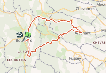
Bouilland circuit Marianne page 22

grasgilbert
Utilisateur

Longueur
18,2 km

Altitude max
618 m

Dénivelé positif
578 m
Km-Effort
26 km

Altitude min
334 m

Dénivelé négatif
577 m
Boucle
Oui
Date de création :
2019-05-23 07:37:06.846
Dernière modification :
2023-05-03 08:22:24.819
5h52
Difficulté : Très difficile

Application GPS de randonnée GRATUITE
 SityTrail
IGN / Instituts géographiques
SityTrail Plus
Le monde est à vous
À propos
Randonnée Marche de 18,2 km à découvrir à Bourgogne-Franche-Comté, Côte-d'Or, Bouilland. Cette randonnée est proposée par grasgilbert.
Description
circuit Marianne
Localisation
Pays :
France
Région :
Bourgogne-Franche-Comté
Département/Province :
Côte-d'Or
Commune :
Bouilland
Localité :
Unknown
Départ:(Dec)
Départ:(UTM)
634709 ; 5221400 (31T) N.
Commentaires
bien