


gr16-florenville-bouillon-montherme-echelles-poi

decoger
Utilisateur

Longueur
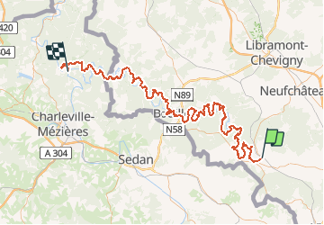
128 km

Altitude max
439 m

Dénivelé positif
3916 m
Km-Effort
181 km

Altitude min
135 m

Dénivelé négatif
4089 m
Boucle
Non
Date de création :
2019-05-30 18:45:45.209
Dernière modification :
2019-05-30 18:48:12.458
--
Difficulté : Inconnu

Application GPS de randonnée GRATUITE
 SityTrail
IGN / Instituts géographiques
SityTrail Plus
Le monde est à vous
À propos
Randonnée Marche de 128 km à découvrir à Wallonie, Luxembourg, Florenville. Cette randonnée est proposée par decoger.
Points d'intérêt


Localisation
Pays :
Belgique
Région :
Wallonie
Département/Province :
Luxembourg
Commune :
Florenville
Localité :
Florenville
Départ:(Dec)
Départ:(UTM)
668129 ; 5508635 (31U) N.
Commentaires