


Maissin Lesse Maissin (14km)

thomas1986
Utilisateur
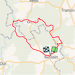

Longueur
13,6 km

Altitude max
395 m

Dénivelé positif
283 m
Km-Effort
17,4 km

Altitude min
259 m

Dénivelé négatif
287 m
Boucle
Oui
Date de création :
2019-06-02 08:57:33.292
Dernière modification :
2019-08-17 09:19:53.946
1h03
Difficulté : Très facile

Application GPS de randonnée GRATUITE
 SityTrail
IGN / Instituts géographiques
SityTrail Plus
Le monde est à vous
À propos
Randonnée V.T.T. de 13,6 km à découvrir à Wallonie, Luxembourg, Paliseul. Cette randonnée est proposée par thomas1986.
Localisation
Pays :
Belgique
Région :
Wallonie
Département/Province :
Luxembourg
Commune :
Paliseul
Localité :
Maissin
Départ:(Dec)
Départ:(UTM)
656317 ; 5537090 (31U) N.
Commentaires