


Haut Roizon - Col de Malissol

maupassant38
Utilisateur
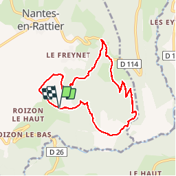

Longueur
8,9 km

Altitude max
1171 m

Dénivelé positif
370 m
Km-Effort
13,8 km

Altitude min
858 m

Dénivelé négatif
366 m
Boucle
Oui
Date de création :
2019-06-07 08:11:56.423
Dernière modification :
2019-06-07 14:18:04.481
2h16
Difficulté : Moyen

Application GPS de randonnée GRATUITE
 SityTrail
IGN / Instituts géographiques
SityTrail Plus
Le monde est à vous
À propos
Randonnée Marche de 8,9 km à découvrir à Auvergne-Rhône-Alpes, Isère, Nantes-en-Rattier. Cette randonnée est proposée par maupassant38.
Localisation
Pays :
France
Région :
Auvergne-Rhône-Alpes
Département/Province :
Isère
Commune :
Nantes-en-Rattier
Localité :
Unknown
Départ:(Dec)
Départ:(UTM)
723454 ; 4977895 (31T) N.
Commentaires