


Lavacherie 13 juin 2019

pierlan
Utilisateur
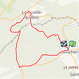

Longueur
16,4 km

Altitude max
594 m

Dénivelé positif
451 m
Km-Effort
22 km

Altitude min
372 m

Dénivelé négatif
456 m
Boucle
Oui
Date de création :
2019-06-12 18:56:03.383
Dernière modification :
2019-06-12 18:58:51.831
4h45
Difficulté : Très difficile

Application GPS de randonnée GRATUITE
 SityTrail
IGN / Instituts géographiques
SityTrail Plus
Le monde est à vous
À propos
Randonnée Marche de 16,4 km à découvrir à Wallonie, Luxembourg, Sainte-Ode. Cette randonnée est proposée par pierlan.
Localisation
Pays :
Belgique
Région :
Wallonie
Département/Province :
Luxembourg
Commune :
Sainte-Ode
Localité :
Lavacherie
Départ:(Dec)
Départ:(UTM)
679749 ; 5547551 (31U) N.
Commentaires