


2013-08-26 Vercors - Le Bruyant - Le Bec d'Aigle

jchezlemas
Utilisateur
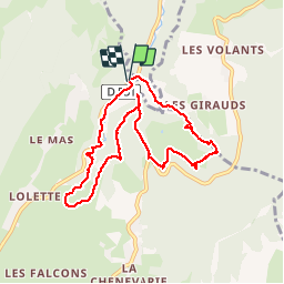

Longueur
9 km

Altitude max
1138 m

Dénivelé positif
367 m
Km-Effort
13,9 km

Altitude min
906 m

Dénivelé négatif
372 m
Boucle
Oui
Date de création :
2014-12-10 00:00:00.0
Dernière modification :
2014-12-10 00:00:00.0
2h56
Difficulté : Moyen

Application GPS de randonnée GRATUITE
 SityTrail
IGN / Instituts géographiques
SityTrail Plus
Le monde est à vous
À propos
Randonnée Marche de 9 km à découvrir à Auvergne-Rhône-Alpes, Isère, Lans-en-Vercors. Cette randonnée est proposée par jchezlemas.
Localisation
Pays :
France
Région :
Auvergne-Rhône-Alpes
Département/Province :
Isère
Commune :
Lans-en-Vercors
Localité :
Unknown
Départ:(Dec)
Départ:(UTM)
704726 ; 5003332 (31T) N.
Commentaires