


pas de l aiguille vercors

grandfifi
Utilisateur
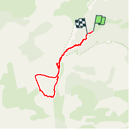

Longueur
6,7 km

Altitude max
1692 m

Dénivelé positif
542 m
Km-Effort
13,8 km

Altitude min
1189 m

Dénivelé négatif
500 m
Boucle
Oui
Date de création :
2019-08-18 08:13:31.06
Dernière modification :
2019-08-19 16:43:08.378
3h49
Difficulté : Moyen

Application GPS de randonnée GRATUITE
 SityTrail
IGN / Instituts géographiques
SityTrail Plus
Le monde est à vous
À propos
Randonnée Marche de 6,7 km à découvrir à Auvergne-Rhône-Alpes, Isère, Chichilianne. Cette randonnée est proposée par grandfifi.
Localisation
Pays :
France
Région :
Auvergne-Rhône-Alpes
Département/Province :
Isère
Commune :
Chichilianne
Localité :
Unknown
Départ:(Dec)
Départ:(UTM)
699549 ; 4965685 (31T) N.
Commentaires