Randonnée V.T.T. Lachapelle-aux-Pots - la Chapelle aux Pots - Savignie - Photo

la Chapelle aux Pots - Savignie

 sebcar
sebcar

Utilisateur

© OpenStreetMap contributors
Longueur
Longueur
19,1 km
Altitude max
Altitude max
237 m
Dénivelé positif
Dénivelé positif
374 m
Km-Effort
Km-Effort  
24 km
Altitude min
Altitude min
84 m
Dénivelé négatif
Dénivelé négatif
374 m
Boucle
Boucle
Oui
Date de création :
2019-08-23 18:13:09.798
Dernière modification :
2019-08-24 12:49:18.958

(1 Avis)

V.T.T.
V.T.T.
1h39
Difficulté : Moyen

Scannez ce code QR pour ouvrir la randonnée dans l'application SityTrail

Application GPS de randonnée GRATUITE

Logo SityTrail SityTrail

IGN / Instituts géographiques

Télécharger SityTrail sur l'App Store Télécharger SityTrail sur Google Play

Logo SityTrail SityTrail World

Le monde est à vous

Télécharger SityTrail sur l'App Store Télécharger SityTrail sur Google Play Télécharger SityTrail sur Huawei AppGallery

À propos

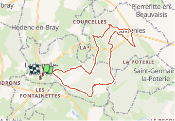
Randonnée V.T.T. de 19,1 km à découvrir à Hauts-de-France, Oise, Lachapelle-aux-Pots. Cette randonnée est proposée par sebcar.

Description

Belle façon de découvrir les caractéristiques paysagères et géologiques du flanc est du pays de Bray.
Attention à Lhuyère le chemin à disparu suite à un "remembrement personnalisé" du cultivateur.

Profil altimétrique

Localisation

Pays :
France
Région :
Hauts-de-France
Département/Province :
Oise
Commune :
Lachapelle-aux-Pots
Localité :
Unknown
Départ:(Dec)
Départ:(UTM)
420392 ; 5477224 (31U) N.

Commentaires

Veuillez vous connecter pour laisser un commentaire ou une note


Randonnées à proximité

Randonnée V.T.T. Pierrefitte-en-Beauvaisis - Grand tour - Photo
V.T.T.
jjeletufe

V.T.T.

(1)
Pierrefitte-en-Beauvaisis, Hauts-de-France, Oise, France
30 km | 35 km-effort
1h 44min
Oui
Randonnée Marche Senantes - Senantes - Photo
Marche
jpblimond

Marche

Moyen
Senantes, Hauts-de-France, Oise, France
18,7 km | 23 km-effort
4h 47min
Oui
Randonnée Marche Lalandelle - Forêt domaniale de Thelle à partir de Lalandelle - Photo
Marche
Marie-Claire-mcp

Marche

Difficile
Lalandelle, Hauts-de-France, Oise, France
11 km | 13,1 km-effort
2h 59min
Oui
Randonnée Marche Lachapelle-aux-Pots - Lachapelle-aux-pots - Héricourt - La Frénoye - Armentières - Photo
Marche
Marie-Claire-mcp

Marche

Difficile
Lachapelle-aux-Pots, Hauts-de-France, Oise, France
10,7 km | 13,7 km-effort
3h 6min
Oui
Randonnée Marche Lachapelle-aux-Pots - Lachapelle aux pots - Armentières 11 km - Photo
Marche
Marie-Claire-mcp

Marche

Difficile
Lachapelle-aux-Pots, Hauts-de-France, Oise, France
10,6 km | 13,5 km-effort
3h 4min
Oui
Randonnée Marche Lachapelle-aux-Pots - Lachapelle aux Pots - Rando santé 1 - Photo
Marche
marcel.F

Marche

Moyen
Lachapelle-aux-Pots, Hauts-de-France, Oise, France
5,6 km | 6,4 km-effort
1h 24min
Oui
Randonnée Marche Lachapelle-aux-Pots - Lachapelle-aux-Pots - autour de la Crapaudière vers 2 - Photo
Marche
marcel.F

Marche

Facile
Lachapelle-aux-Pots, Hauts-de-France, Oise, France
9,9 km | 11,5 km-effort
2h 32min
Oui
Randonnée Marche Lachapelle-aux-Pots - Lachapelle-aux-Pots - autour de la Crapaudière - Photo
Marche
marcel.F

Marche

Facile
Lachapelle-aux-Pots, Hauts-de-France, Oise, France
9,4 km | 10,9 km-effort
2h 25min
Oui
Randonnée Marche Lachapelle-aux-Pots - Lachapelle aux pots Gare - Photo
Marche
Marie-Claire-mcp

Marche

Moyen
Lachapelle-aux-Pots, Hauts-de-France, Oise, France
10,6 km | 12,4 km-effort
2h 37min
Oui


Fermer
Mes abonnements