![](/images/other/stat-length.png)
![Randonnée V.T.T. Sermamagny - vtt-malsaucy-gyro-valdoie - Photo](https://media.geolcdn.com/t/1900/400/ext.pjpeg?maxdim=2&url=https%3A%2F%2Fstatic1.geolcdn.com%2Fsiteimages%2Fupload%2Ffiles%2F1524743154velo.jpg)
vtt-malsaucy-gyro-valdoie
benoit747
Utilisateur
![Longueur](/images/other/stat-length.png)
Longueur
30 km
![Altitude max](https://static1.geolcdn.com/siteimages/upload/files/1508320355ic_sort_altitude_max_24dp.png)
Altitude max
553 m
![Dénivelé positif](https://static1.geolcdn.com/siteimages/upload/files/1508320355ic_sort_den_pos_24dp.png)
Dénivelé positif
492 m
![Km-Effort](/images/other/stat-length.png)
Km-Effort
37 km
![Altitude min](https://static1.geolcdn.com/siteimages/upload/files/1508320355ic_sort_altitude_min_24dp.png)
Altitude min
371 m
![Dénivelé négatif](https://static1.geolcdn.com/siteimages/upload/files/1508320355ic_sort_den_neg_24dp.png)
Dénivelé négatif
493 m
![Boucle](https://static1.geolcdn.com/siteimages/upload/files/16400158638029165_repeat_loop_refresh_sync_direction_icon.png)
Boucle
Oui
Date de création :
2019-10-11 16:11:45.069
Dernière modification :
2019-10-13 08:26:11.359
![V.T.T.](https://static1.geolcdn.com/sitytour/trail-icons/202.png)
2h27
Difficulté : Moyen
![Scannez ce code QR pour ouvrir la randonnée dans l'application SityTrail](https://capi.geolives.com/qq0zvz2zws4bq2lad0pu/sitytour/trails/2227392/qr.png?size=200)
Application GPS de randonnée GRATUITE
À propos
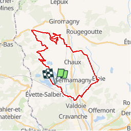
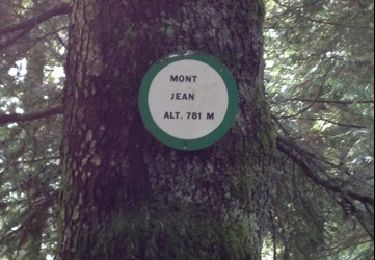
Randonnée V.T.T. de 30 km à découvrir à Bourgogne-Franche-Comté, Territoire-de-Belfort, Sermamagny. Cette randonnée est proposée par benoit747.
Description
un tour très sympa et accessible de 30 km.
Départ du Malsaucy, parking facile.
le dénivelé réel est de 400m
Localisation
Pays :
France
Région :
Bourgogne-Franche-Comté
Département/Province :
Territoire-de-Belfort
Commune :
Sermamagny
Localité :
Unknown
Départ:(Dec)
Départ:(UTM)
335896 ; 5283463 (32T) N.
Commentaires
Randonnées à proximité
![Randonnée Marche Belfort - Offemont - La ballade des Champs Cerisiers - Photo](https://media.geolcdn.com/t/375/260/ext.jpg?maxdim=2&url=https%3A%2F%2Fstatic1.geolcdn.com%2Fsiteimages%2Fupload%2Ffiles%2F1553511878bg_sport_marche.png)
![Marche Marche](https://static1.geolcdn.com/sitytour/trail-icons/101.png)
Offemont - La ballade des Champs Cerisiers
Marche
Facile
(1)
Belfort,
Bourgogne-Franche-Comté,
Territoire-de-Belfort,
France
![](/images/other/stat-length.png)
8,8 km | 10,8 km-effort
Inconnu
![](https://static1.geolcdn.com/siteimages/upload/files/16400158638029165_repeat_loop_refresh_sync_direction_icon.png)
Oui
![Randonnée Marche Sermamagny - Veronne PC - Photo](https://media.geolcdn.com/t/375/260/ext.jpg?maxdim=2&url=https%3A%2F%2Fstatic1.geolcdn.com%2Fsiteimages%2Fupload%2Ffiles%2F1553511878bg_sport_marche.png)
![Marche Marche](https://static1.geolcdn.com/sitytour/trail-icons/101.png)
Veronne PC
Marche
Très facile
(2)
Sermamagny,
Bourgogne-Franche-Comté,
Territoire-de-Belfort,
France
![](/images/other/stat-length.png)
8,1 km | 9 km-effort
1h 59min
![](https://static1.geolcdn.com/siteimages/upload/files/16400158638029165_repeat_loop_refresh_sync_direction_icon.png)
Oui
![Randonnée Marche Châlonvillars - Châlonvillars - Fort du Salbert - Evette-Salbert - Photo](https://media.geolcdn.com/t/375/260/ext.jpg?maxdim=2&url=https%3A%2F%2Fmedia.geolcdn.com%2Ff%2F30a56d40-1ac0-4227-a497-f489c67ce1fe.jpg)
![Marche Marche](https://static1.geolcdn.com/sitytour/trail-icons/101.png)
Châlonvillars - Fort du Salbert - Evette-Salbert
Marche
Difficile
(1)
Châlonvillars,
Bourgogne-Franche-Comté,
Haute-Saône,
France
![](/images/other/stat-length.png)
11 km | 15,8 km-effort
3h 36min
![](https://static1.geolcdn.com/siteimages/upload/files/16400158638029165_repeat_loop_refresh_sync_direction_icon.png)
Oui
![Randonnée A pied Offemont - Sentier de la Roselière - Photo](https://media.geolcdn.com/t/375/260/ext.jpg?maxdim=2&url=https%3A%2F%2Fmedia.geolcdn.com%2Ff%2Fc8e60aaf-8ba5-407b-b750-77a1aea99966.jpeg)
![A pied A pied](https://static1.geolcdn.com/sitytour/trail-icons/100.png)
Sentier de la Roselière
A pied
Facile
Offemont,
Bourgogne-Franche-Comté,
Territoire-de-Belfort,
France
![](/images/other/stat-length.png)
3,9 km | 4,3 km-effort
58min
![](https://static1.geolcdn.com/siteimages/upload/files/16400158638029165_repeat_loop_refresh_sync_direction_icon.png)
Oui
![Randonnée Marche Châlonvillars - Châlonvillars - les étangs - fort du Salbert - grottes Cravanche - Photo](https://media.geolcdn.com/t/375/260/ext.jpg?maxdim=2&url=https%3A%2F%2Fmedia.geolcdn.com%2Ff%2F2f213c45-2c85-4a46-8dec-f1e49805b183.jpg)
![Marche Marche](https://static1.geolcdn.com/sitytour/trail-icons/101.png)
Châlonvillars - les étangs - fort du Salbert - grottes Cravanche
Marche
Moyen
Châlonvillars,
Bourgogne-Franche-Comté,
Haute-Saône,
France
![](/images/other/stat-length.png)
13,2 km | 20 km-effort
2h 46min
![](https://static1.geolcdn.com/siteimages/upload/files/16400158638029165_repeat_loop_refresh_sync_direction_icon.png)
Oui
![Randonnée Randonnée équestre Lachapelle-sous-Chaux - Lachapelle-sous-chaux / Planche des belles filles - Photo](https://media.geolcdn.com/t/375/260/ext.jpg?maxdim=2&url=https%3A%2F%2Fstatic1.geolcdn.com%2Fsiteimages%2Fupload%2Ffiles%2F1524743154cheval.jpg)
![Randonnée équestre Randonnée équestre](https://static1.geolcdn.com/sitytour/trail-icons/301.png)
Lachapelle-sous-chaux / Planche des belles filles
Randonnée équestre
Difficile
(1)
Lachapelle-sous-Chaux,
Bourgogne-Franche-Comté,
Territoire-de-Belfort,
France
![](/images/other/stat-length.png)
25 km | 37 km-effort
4h 26min
![](https://static1.geolcdn.com/siteimages/upload/files/16400158638029165_repeat_loop_refresh_sync_direction_icon.png)
Oui
![Randonnée Marche Châlonvillars - Chalonvillars - fort du Salbert - Photo](https://media.geolcdn.com/t/375/260/ext.jpg?maxdim=2&url=https%3A%2F%2Fmedia.geolcdn.com%2Ff%2Fd94b0325-7f77-419f-a66d-33ccd4a2fe00.jpg)
![Marche Marche](https://static1.geolcdn.com/sitytour/trail-icons/101.png)
Chalonvillars - fort du Salbert
Marche
Facile
Châlonvillars,
Bourgogne-Franche-Comté,
Haute-Saône,
France
![](/images/other/stat-length.png)
9,7 km | 14,1 km-effort
2h 27min
![](https://static1.geolcdn.com/siteimages/upload/files/16400158638029165_repeat_loop_refresh_sync_direction_icon.png)
Oui
![Randonnée V.T.T. Belfort - tour de la miotte Blingarno - Photo](https://media.geolcdn.com/t/375/260/ext.jpg?maxdim=2&url=https%3A%2F%2Fservices.sitytrail.com%2FGeolivesWS%2FDownloadMedia.ashx%3FTrailID%3D219178%26Media%3Dfix__20130905100532.jpg)
![V.T.T. V.T.T.](https://static1.geolcdn.com/sitytour/trail-icons/202.png)
tour de la miotte Blingarno
V.T.T.
Moyen
Belfort,
Bourgogne-Franche-Comté,
Territoire-de-Belfort,
France
![](/images/other/stat-length.png)
10,5 km | 12,4 km-effort
52min
![](https://static1.geolcdn.com/siteimages/upload/files/16400158638029165_repeat_loop_refresh_sync_direction_icon.png)
Oui
![Randonnée V.T.T. Chaux - mont jean Giro - Photo](https://media.geolcdn.com/t/375/260/ext.jpg?maxdim=2&url=https%3A%2F%2Fservices.sitytrail.com%2FGeolivesWS%2FDownloadMedia.ashx%3FTrailID%3D155650%26Media%3D20120923134909.jpg)
![V.T.T. V.T.T.](https://static1.geolcdn.com/sitytour/trail-icons/202.png)
mont jean Giro
V.T.T.
Très facile
(1)
Chaux,
Bourgogne-Franche-Comté,
Territoire-de-Belfort,
France
![](/images/other/stat-length.png)
24 km | 32 km-effort
2h 4min
![](https://static1.geolcdn.com/siteimages/upload/files/16400158638029165_repeat_loop_refresh_sync_direction_icon.png)
Oui