![](/images/other/stat-length.png)
![Randonnée Marche Saillans - Rocher de la Cresta - Photo](https://media.geolcdn.com/t/1900/400/ext.pjpeg?maxdim=2&url=https%3A%2F%2Fmedia.geolcdn.com%2Ff%2Faa7a3f17-51f8-4e93-a591-96f5570c97c2.jpg)
Rocher de la Cresta
ajd26
Utilisateur
![Longueur](/images/other/stat-length.png)
Longueur
13,1 km
![Altitude max](https://static1.geolcdn.com/siteimages/upload/files/1508320355ic_sort_altitude_max_24dp.png)
Altitude max
888 m
![Dénivelé positif](https://static1.geolcdn.com/siteimages/upload/files/1508320355ic_sort_den_pos_24dp.png)
Dénivelé positif
776 m
![Km-Effort](/images/other/stat-length.png)
Km-Effort
23 km
![Altitude min](https://static1.geolcdn.com/siteimages/upload/files/1508320355ic_sort_altitude_min_24dp.png)
Altitude min
280 m
![Dénivelé négatif](https://static1.geolcdn.com/siteimages/upload/files/1508320355ic_sort_den_neg_24dp.png)
Dénivelé négatif
775 m
![Boucle](https://static1.geolcdn.com/siteimages/upload/files/16400158638029165_repeat_loop_refresh_sync_direction_icon.png)
Boucle
Oui
Date de création :
2019-12-12 08:42:40.0
Dernière modification :
2019-12-12 17:30:41.991
![Marche](https://static1.geolcdn.com/sitytour/trail-icons/101.png)
6h00
Difficulté : Difficile
![Scannez ce code QR pour ouvrir la randonnée dans l'application SityTrail](https://capi.geolives.com/qq0zvz2zws4bq2lad0pu/sitytour/trails/2283719/qr.png?size=200)
Application GPS de randonnée GRATUITE
À propos
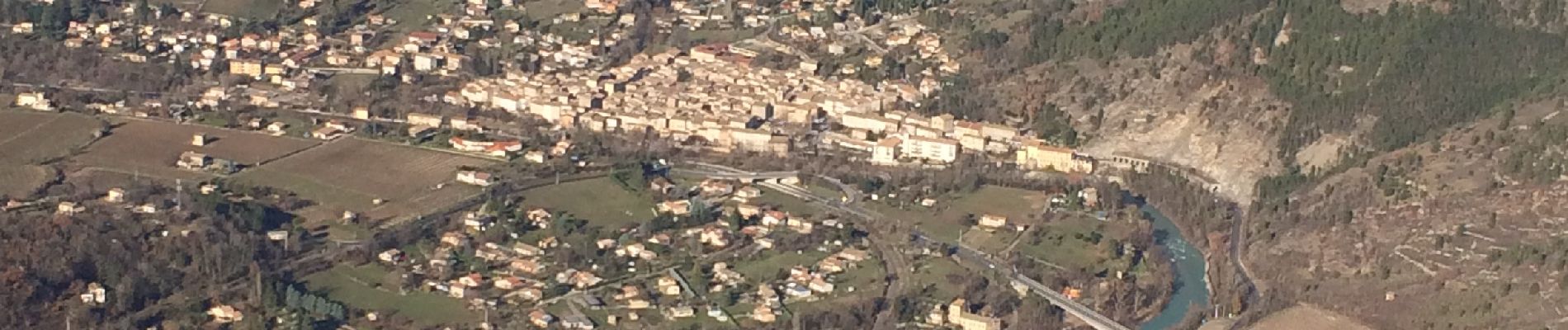
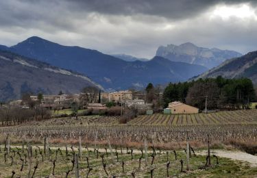
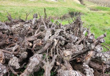
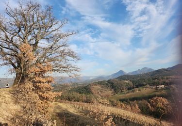
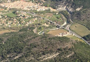
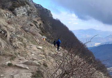
Randonnée Marche de 13,1 km à découvrir à Auvergne-Rhône-Alpes, Drôme, Saillans. Cette randonnée est proposée par ajd26.
Description
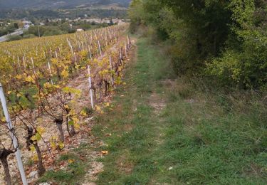
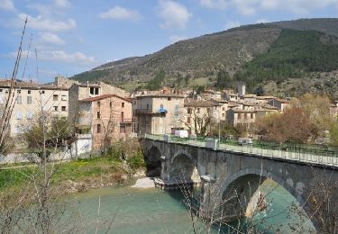
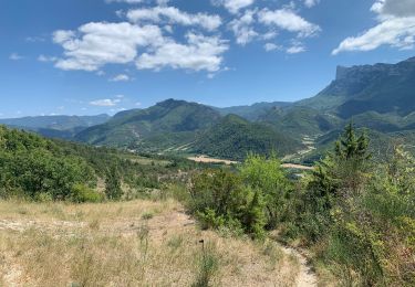
Départ de Saillans,route du col de la Chaudière, col d’Espenel, rochers de la Cresta (il faut mettre les mains dans le final). Superbe panorama sur la vallée de la Drôme et retour par Castel-Arnaud
Localisation
Pays :
France
Région :
Auvergne-Rhône-Alpes
Département/Province :
Drôme
Commune :
Saillans
Localité :
Unknown
Départ:(Dec)
Départ:(UTM)
674342 ; 4951062 (31T) N.
Commentaires
Randonnées à proximité
![Randonnée Marche Vercheny - Vercheny Chateau du Barry 14 km - Photo](https://media.geolcdn.com/t/375/260/ext.jpg?maxdim=2&url=https%3A%2F%2Fmedia.geolcdn.com%2Ff%2F519ec2eb-eec0-4702-a29a-2c5cd69166ae.jpg)
![Marche Marche](https://static1.geolcdn.com/sitytour/trail-icons/101.png)
Vercheny Chateau du Barry 14 km
Marche
Moyen
(1)
Vercheny,
Auvergne-Rhône-Alpes,
Drôme,
France
![](/images/other/stat-length.png)
14,2 km | 23 km-effort
5h 11min
![](https://static1.geolcdn.com/siteimages/upload/files/16400158638029165_repeat_loop_refresh_sync_direction_icon.png)
Oui
![Randonnée V.T.T. Saillans - Grande Traversée des PréAlpes à VTT : variante Saillans - Montmorin - Photo](https://media.geolcdn.com/t/375/260/ext.jpg?maxdim=2&url=https%3A%2F%2Fservices.sitytrail.com%2FGeolivesWS%2FDownloadMedia.ashx%3FTrailID%3D102178%26Media%3D2569_1.jpg)
![V.T.T. V.T.T.](https://static1.geolcdn.com/sitytour/trail-icons/202.png)
Grande Traversée des PréAlpes à VTT : variante Saillans - Montmorin
V.T.T.
Très difficile
(1)
Saillans,
Auvergne-Rhône-Alpes,
Drôme,
France
![](/images/other/stat-length.png)
74 km | 113 km-effort
11h 0min
![](https://static1.geolcdn.com/siteimages/upload/files/16400158638029165_repeat_loop_refresh_sync_direction_icon.png)
Non
![Randonnée Marche Saint-Sauveur-en-Diois - saint sauveur en diois - Photo](https://media.geolcdn.com/t/375/260/ext.jpg?maxdim=2&url=https%3A%2F%2Fmedia.geolcdn.com%2Ff%2F571ebd87-a7e9-4b87-af12-17cecb59278a.jpg)
![Marche Marche](https://static1.geolcdn.com/sitytour/trail-icons/101.png)
saint sauveur en diois
Marche
Très facile
Saint-Sauveur-en-Diois,
Auvergne-Rhône-Alpes,
Drôme,
France
![](/images/other/stat-length.png)
5 km | 6,7 km-effort
1h 46min
![](https://static1.geolcdn.com/siteimages/upload/files/16400158638029165_repeat_loop_refresh_sync_direction_icon.png)
Oui
![Randonnée Marche Aubenasson - saint Michel Aubenasson - Photo](https://media.geolcdn.com/t/375/260/ext.jpg?maxdim=2&url=https%3A%2F%2Fmedia.geolcdn.com%2Ff%2F9cfb9e95-478d-41e2-9a6e-6de46d17856a.jpg)
![Marche Marche](https://static1.geolcdn.com/sitytour/trail-icons/101.png)
saint Michel Aubenasson
Marche
Moyen
Aubenasson,
Auvergne-Rhône-Alpes,
Drôme,
France
![](/images/other/stat-length.png)
19,7 km | 24 km-effort
3h 45min
![](https://static1.geolcdn.com/siteimages/upload/files/16400158638029165_repeat_loop_refresh_sync_direction_icon.png)
Non
![Randonnée Marche Saillans - Cresta - Photo](https://media.geolcdn.com/t/375/260/ext.jpg?maxdim=2&url=https%3A%2F%2Fmedia.geolcdn.com%2Ff%2Fdda4974b-08c2-4620-b53f-ea2254640dae.jpg)
![Marche Marche](https://static1.geolcdn.com/sitytour/trail-icons/101.png)
Cresta
Marche
Très difficile
Saillans,
Auvergne-Rhône-Alpes,
Drôme,
France
![](/images/other/stat-length.png)
14 km | 27 km-effort
6h 12min
![](https://static1.geolcdn.com/siteimages/upload/files/16400158638029165_repeat_loop_refresh_sync_direction_icon.png)
Oui
![Randonnée Marche Saillans - 26 gaudichard zel - Photo](https://media.geolcdn.com/t/375/260/ext.jpg?maxdim=2&url=https%3A%2F%2Fmedia.geolcdn.com%2Ff%2Fb5e022d8-7c23-4271-85bc-1b741ca6ca0c.jpg)
![Marche Marche](https://static1.geolcdn.com/sitytour/trail-icons/101.png)
26 gaudichard zel
Marche
Moyen
Saillans,
Auvergne-Rhône-Alpes,
Drôme,
France
![](/images/other/stat-length.png)
18,2 km | 32 km-effort
7h 42min
![](https://static1.geolcdn.com/siteimages/upload/files/16400158638029165_repeat_loop_refresh_sync_direction_icon.png)
Oui
![Randonnée Marche Saillans - Saillans Chapelle St Christophe 14km. - Photo](https://media.geolcdn.com/t/375/260/ext.jpg?maxdim=2&url=https%3A%2F%2Fmedia.geolcdn.com%2Ff%2Fdbc3dc28-619e-4ea9-9959-103bf755836c.jpg)
![Marche Marche](https://static1.geolcdn.com/sitytour/trail-icons/101.png)
Saillans Chapelle St Christophe 14km.
Marche
Moyen
Saillans,
Auvergne-Rhône-Alpes,
Drôme,
France
![](/images/other/stat-length.png)
14,1 km | 20 km-effort
4h 42min
![](https://static1.geolcdn.com/siteimages/upload/files/16400158638029165_repeat_loop_refresh_sync_direction_icon.png)
Oui
![Randonnée Marche Saillans - Grande boucle au départ de Saillans - Photo](https://media.geolcdn.com/t/375/260/ext.jpg?maxdim=2&url=https%3A%2F%2Fmedia.geolcdn.com%2Ff%2Fa7f6ee47-9dee-488a-8459-0b79be140170.jpg)
![Marche Marche](https://static1.geolcdn.com/sitytour/trail-icons/101.png)
Grande boucle au départ de Saillans
Marche
Difficile
Saillans,
Auvergne-Rhône-Alpes,
Drôme,
France
![](/images/other/stat-length.png)
32 km | 45 km-effort
8h 0min
![](https://static1.geolcdn.com/siteimages/upload/files/16400158638029165_repeat_loop_refresh_sync_direction_icon.png)
Oui
![Randonnée Marche Chastel-Arnaud - pas de la motte - Photo](https://media.geolcdn.com/t/375/260/ext.jpg?maxdim=2&url=https%3A%2F%2Fmedia.geolcdn.com%2Ff%2F7b4c7e05-f42e-4dda-85e0-319d4c57603e.jpg)
![Marche Marche](https://static1.geolcdn.com/sitytour/trail-icons/101.png)
pas de la motte
Marche
Difficile
Chastel-Arnaud,
Auvergne-Rhône-Alpes,
Drôme,
France
![](/images/other/stat-length.png)
12 km | 27 km-effort
6h 4min
![](https://static1.geolcdn.com/siteimages/upload/files/16400158638029165_repeat_loop_refresh_sync_direction_icon.png)
Non