


Pont st Vincent-circuit Ste-Anne

geranimo
Utilisateur
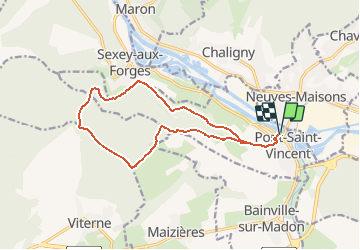

Longueur
13,6 km

Altitude max
399 m

Dénivelé positif
321 m
Km-Effort
17,9 km

Altitude min
217 m

Dénivelé négatif
321 m
Boucle
Oui
Date de création :
2020-01-29 19:23:38.208
Dernière modification :
2020-01-29 23:04:31.199
--
Difficulté : Moyen

Application GPS de randonnée GRATUITE
 SityTrail
IGN / Instituts géographiques
SityTrail Plus
Le monde est à vous
À propos
Randonnée A pied de 13,6 km à découvrir à Grand Est, Meurthe-et-Moselle, Pont-Saint-Vincent. Cette randonnée est proposée par geranimo.
Localisation
Pays :
France
Région :
Grand Est
Département/Province :
Meurthe-et-Moselle
Commune :
Pont-Saint-Vincent
Localité :
Unknown
Départ:(Dec)
Départ:(UTM)
286097 ; 5387801 (32U) N.
Commentaires