


Vlh-StMarc

thomarche
Utilisateur
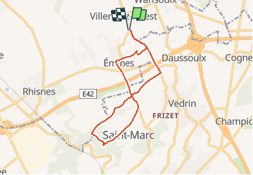

Longueur
12,1 km

Altitude max
196 m

Dénivelé positif
152 m
Km-Effort
14,1 km

Altitude min
141 m

Dénivelé négatif
152 m
Boucle
Oui
Date de création :
2020-03-24 15:15:12.0
Dernière modification :
2020-03-24 17:05:41.466
1h50
Difficulté : Inconnu

Application GPS de randonnée GRATUITE
 SityTrail
IGN / Instituts géographiques
SityTrail Plus
Le monde est à vous
À propos
Randonnée V.T.C. de 12,1 km à découvrir à Wallonie, Namur, La Bruyère. Cette randonnée est proposée par thomarche.
Localisation
Pays :
Belgique
Région :
Wallonie
Département/Province :
Namur
Commune :
La Bruyère
Localité :
Villers-lez-Heest
Départ:(Dec)
Départ:(UTM)
630999 ; 5598661 (31U) N.
Commentaires