


Le Serpont 11 juin 2020

pierlan
Utilisateur
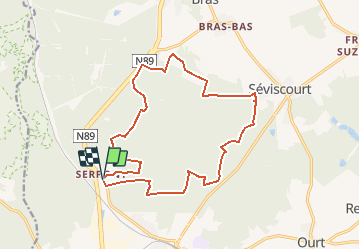

Longueur
16 km

Altitude max
573 m

Dénivelé positif
369 m
Km-Effort
21 km

Altitude min
440 m

Dénivelé négatif
367 m
Boucle
Oui
Date de création :
2020-06-06 18:49:47.729
Dernière modification :
2020-06-06 18:58:36.082
3h20
Difficulté : Très facile

Application GPS de randonnée GRATUITE
 SityTrail
IGN / Instituts géographiques
SityTrail Plus
Le monde est à vous
À propos
Randonnée Trail de 16 km à découvrir à Wallonie, Luxembourg, Libramont-Chevigny. Cette randonnée est proposée par pierlan.
Localisation
Pays :
Belgique
Région :
Wallonie
Département/Province :
Luxembourg
Commune :
Libramont-Chevigny
Localité :
Unknown
Départ:(Dec)
Départ:(UTM)
668831 ; 5534183 (31U) N.
Commentaires