![](/images/other/stat-length.png)
![Randonnée Marche Aramon - ARAMON - COLLINES DE DEVE - 15.1 Km - 05h00 Heures - Dénivelé 200 m - Photo](https://media.geolcdn.com/t/1900/400/ext.pjpeg?maxdim=2&url=https%3A%2F%2Fstatic1.geolcdn.com%2Fsiteimages%2Fupload%2Ffiles%2F1553511878bg_sport_marche.png)
ARAMON - COLLINES DE DEVE - 15.1 Km - 05h00 Heures - Dénivelé 200 m
dansmabulle
Utilisateur
![Longueur](/images/other/stat-length.png)
![Altitude max](https://static1.geolcdn.com/siteimages/upload/files/1508320355ic_sort_altitude_max_24dp.png)
![Dénivelé positif](https://static1.geolcdn.com/siteimages/upload/files/1508320355ic_sort_den_pos_24dp.png)
![Km-Effort](/images/other/stat-length.png)
![Altitude min](https://static1.geolcdn.com/siteimages/upload/files/1508320355ic_sort_altitude_min_24dp.png)
![Dénivelé négatif](https://static1.geolcdn.com/siteimages/upload/files/1508320355ic_sort_den_neg_24dp.png)
![Boucle](https://static1.geolcdn.com/siteimages/upload/files/16400158638029165_repeat_loop_refresh_sync_direction_icon.png)
![Marche](https://static1.geolcdn.com/sitytour/trail-icons/101.png)
4h13
Difficulté : Facile
![Scannez ce code QR pour ouvrir la randonnée dans l'application SityTrail](https://capi.geolives.com/qq0zvz2zws4bq2lad0pu/sitytour/trails/244323/qr.png?size=200)
Application GPS de randonnée GRATUITE
À propos
Randonnée Marche de 15 km à découvrir à Occitanie, Gard, Aramon. Cette randonnée est proposée par dansmabulle.
Description
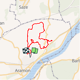
ARAMON - COLLINES DE DEVE15.1 Km - 05:00 Heures - Dénivelé 200 mètres
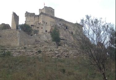
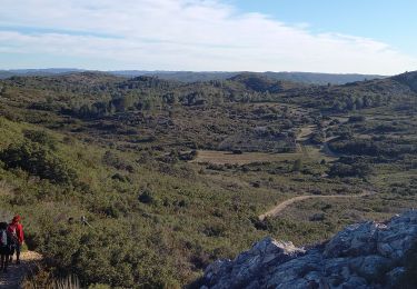
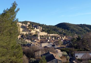
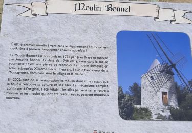
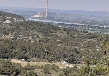
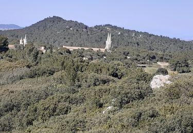
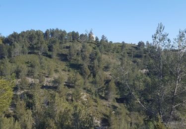
Départ randonnée : Pour le parking, suivre le fléchage « capitelles » dès le petit rond point d’Aramon (Gard 30) Des Capitelles d’Aramon aux collines de Dève.Circuit de 15km et un cumul de dénivelé de 475m.Nous partons à 9h17 pour rentrer à 17h09 avec un groupe certes lent, mais il faut du temps pour découvrir les 15 Capitelles ,7 sur le début (9h17 à 10h25) et 8 à la fin du circuit(16h29 à 17h09) et admirer les vues sur le Rhône , Avignon, Barbentane,… et au loin, les alpilles , le lubéron, le ventoux.Régulièrement on passe par des petits sommets ou des crêtes .Le reste du parcours fait découvrir une ancienne demeure avec un magnifique pigeonnier,une grotte avec le fond percé, le Vallon de Déve que vous surplomberez du sommet d’une falaise(On n’imagine pas trouver autant d’eau dans ces lieux….Un barrage(endommagé) visible par l’autre rive ferme ce vallon d’où l’on entend l’eau couler).A l’autre bout (aussi non visible ) se trouve le Moulin de Dève qui utilisait l’eau de ce « ruisseau ».Plus loin (2/3 du parcours) on trouve la source de Dève (où vous pouvez refaire le plein d’eau ), puis le rocher pointu. Bonne randonnée
Localisation
Commentaires
Randonnées à proximité
![Randonnée Marche Boulbon - Boulbon PR40 - Photo](https://media.geolcdn.com/t/375/260/ext.jpg?maxdim=2&url=https%3A%2F%2Fservices.sitytrail.com%2FGeolivesWS%2FDownloadMedia.ashx%3FTrailID%3D233193%26Media%3D20131101145846.jpg)
![Marche Marche](https://static1.geolcdn.com/sitytour/trail-icons/101.png)
Marche
![](/images/other/stat-length.png)
![](https://static1.geolcdn.com/siteimages/upload/files/16400158638029165_repeat_loop_refresh_sync_direction_icon.png)
![Randonnée Marche Aramon - Les Castillones - Photo](https://media.geolcdn.com/t/375/260/ext.jpg?maxdim=2&url=https%3A%2F%2Fmedia.geolcdn.com%2Ff%2Fed06a468-8718-46c2-85f4-099025efba3e.jpg)
![Marche Marche](https://static1.geolcdn.com/sitytour/trail-icons/101.png)
![Randonnée Marche Boulbon - Boulbon Barbentane Frigolet - Photo](https://media.geolcdn.com/t/375/260/ext.jpg?maxdim=2&url=https%3A%2F%2Fmedia.geolcdn.com%2Ff%2Fdb98e8af-4738-41d8-a5cc-4102fa5d0520.jpg)
![Marche Marche](https://static1.geolcdn.com/sitytour/trail-icons/101.png)
Marche
![](/images/other/stat-length.png)
![](https://static1.geolcdn.com/siteimages/upload/files/16400158638029165_repeat_loop_refresh_sync_direction_icon.png)
![Randonnée A pied Boulbon - Boulbon et le Moulin Bonnet - Photo](https://media.geolcdn.com/t/375/260/ext.jpg?maxdim=2&url=https%3A%2F%2Fstatic1.geolcdn.com%2Fsiteimages%2Fupload%2Ffiles%2F1545311037marcheuse_200dpi.jpg)
![A pied A pied](https://static1.geolcdn.com/sitytour/trail-icons/100.png)
A pied
![](/images/other/stat-length.png)
![](https://static1.geolcdn.com/siteimages/upload/files/16400158638029165_repeat_loop_refresh_sync_direction_icon.png)
![Randonnée Marche Théziers - 30-Théziers-Fournès Estézargues Domazan - Photo](https://media.geolcdn.com/t/375/260/ext.jpg?maxdim=2&url=https%3A%2F%2Fstatic1.geolcdn.com%2Fsiteimages%2Fupload%2Ffiles%2F1553511878bg_sport_marche.png)
![Marche Marche](https://static1.geolcdn.com/sitytour/trail-icons/101.png)
Marche
![](/images/other/stat-length.png)
![](https://static1.geolcdn.com/siteimages/upload/files/16400158638029165_repeat_loop_refresh_sync_direction_icon.png)
![Randonnée Marche Tarascon - de l abbaye de frigolet à boulbon - Photo](https://media.geolcdn.com/t/375/260/ext.jpg?maxdim=2&url=https%3A%2F%2Fmedia.geolcdn.com%2Ff%2F48889ee4-d649-4c3a-9df2-641db31e8693.jpg)
![Marche Marche](https://static1.geolcdn.com/sitytour/trail-icons/101.png)
Marche
![](/images/other/stat-length.png)
![](https://static1.geolcdn.com/siteimages/upload/files/16400158638029165_repeat_loop_refresh_sync_direction_icon.png)
![Randonnée Marche Boulbon - Boulbon Vallon des Cavaillonès - Photo](https://media.geolcdn.com/t/375/260/ext.jpg?maxdim=2&url=https%3A%2F%2Fmedia.geolcdn.com%2Ff%2F26ae9ef7-5be3-48ee-bebe-b9320bcbd58f.jpg)
![Marche Marche](https://static1.geolcdn.com/sitytour/trail-icons/101.png)
Marche
![](/images/other/stat-length.png)
![](https://static1.geolcdn.com/siteimages/upload/files/16400158638029165_repeat_loop_refresh_sync_direction_icon.png)
![Randonnée Marche Tarascon - FRIGOLET Gratte Semelle - Photo](https://media.geolcdn.com/t/375/260/ext.jpg?maxdim=2&url=https%3A%2F%2Fmedia.geolcdn.com%2Ff%2F4245b54d-ccac-48c1-b4a1-cf4227c37eb7.jpg)
![Marche Marche](https://static1.geolcdn.com/sitytour/trail-icons/101.png)
Marche
![](/images/other/stat-length.png)
![](https://static1.geolcdn.com/siteimages/upload/files/16400158638029165_repeat_loop_refresh_sync_direction_icon.png)
![Randonnée Marche Boulbon - Boulbon Moulin Montagnette - Photo](https://media.geolcdn.com/t/375/260/ext.jpg?maxdim=2&url=https%3A%2F%2Fmedia.geolcdn.com%2Ff%2F5eeb5339-50ef-462f-a489-97fdbf215d1e.jpg)
![Marche Marche](https://static1.geolcdn.com/sitytour/trail-icons/101.png)
Marche
![](/images/other/stat-length.png)
![](https://static1.geolcdn.com/siteimages/upload/files/16400158638029165_repeat_loop_refresh_sync_direction_icon.png)