Randonnée Marche Biederthal - JD 15/20 Pedibus Biederthal - Photo

JD 15/20 Pedibus Biederthal

 argonneuweg
argonneuweg

Utilisateur

© OpenStreetMap contributors
Longueur
Longueur
8,2 km
Altitude max
Altitude max
526 m
Dénivelé positif
Dénivelé positif
240 m
Km-Effort
Km-Effort  
11,4 km
Altitude min
Altitude min
382 m
Dénivelé négatif
Dénivelé négatif
239 m
Boucle
Boucle
Oui
Date de création :
2020-09-24 08:49:04.0
Dernière modification :
2020-12-15 17:28:21.764

(1 Avis)

Marche
Marche
2h33
Difficulté : Inconnu

Scannez ce code QR pour ouvrir la randonnée dans l'application SityTrail

Application GPS de randonnée GRATUITE

Logo SityTrail SityTrail

IGN / Instituts géographiques

Télécharger SityTrail sur l'App Store Télécharger SityTrail sur Google Play

Logo SityTrail SityTrail World

Le monde est à vous

Télécharger SityTrail sur l'App Store Télécharger SityTrail sur Google Play Télécharger SityTrail sur Huawei AppGallery

À propos

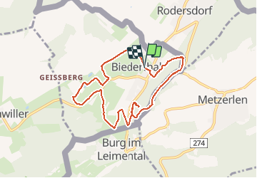
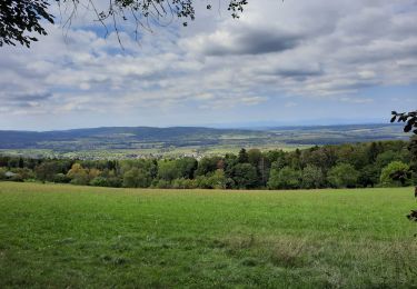
Randonnée Marche de 8,2 km à découvrir à Grand Est, Haut-Rhin, Biederthal. Cette randonnée est proposée par argonneuweg.

Description

Un début de parcours dans la jolie campagne de Biederthal, puis montée vers la crête qui sépare la France et la Suisse.
Les 4 premiers km sont très faciles et la dernière partie est plus difficile : il est alors possible de l'éviter en rentrant directement au village par la D23.

Profil altimétrique

Photos

Localisation

Pays :
France
Région :
Grand Est
Département/Province :
Haut-Rhin
Commune :
Biederthal
Localité :
Unknown
Départ:(UTM)
382970 ; 5258718 (32T) N.

Commentaires

Veuillez vous connecter pour laisser un commentaire ou une note


Randonnées à proximité

Randonnée Marche Wolschwiller - Reco Rando CLAS du 09/05/2024 - Photo
Marche
boubou68

Marche

Très difficile
Wolschwiller, Grand Est, Haut-Rhin, France
18,9 km | 28 km-effort
3h 54min
Oui
Randonnée Marche Wolschwiller - Le sentier des douaniers - Wolschwiller - Photo
Marche
helmut68

Marche

Moyen
(1)
Wolschwiller, Grand Est, Haut-Rhin, France
12,2 km | 18,1 km-effort
3h 30min
Oui
Randonnée Marche Wolschwiller - wolschwiller - Photo
Marche
jcguew

Marche

Facile
Wolschwiller, Grand Est, Haut-Rhin, France
7,3 km | 12,7 km-effort
4h 15min
Non
Randonnée Marche Bättwil - Flüh - Mariastein - Laufen - Photo
Marche
GUIDE+

Marche

Très facile
Bättwil, Soleure, Bezirk Dorneck, Suisse
10,8 km | 17,9 km-effort
Inconnu
Non
Randonnée Marche Wolschwiller - Rando Wolfschwiller..Canyon de Biederthal..14Km.D+/- : 615m - Photo
Marche
boubou68

Marche

Très difficile
Wolschwiller, Grand Est, Haut-Rhin, France
14,1 km | 22 km-effort
5h 4min
Oui
Randonnée A pied Oltingue - Chateau du Landskron  - Photo
A pied
heurtinpatrick

A pied

Moyen
Oltingue, Grand Est, Haut-Rhin, France
18,6 km | 27 km-effort
6h 6min
Oui
Randonnée Marche Wolschwiller - wolschwiller- Landskron - Photo
Marche
chantalwaltzer

Marche

Wolschwiller, Grand Est, Haut-Rhin, France
26 km | 39 km-effort
6h 47min
Oui
Randonnée A pied Wolschwiller - un pied sur le territoire suisse - Photo
A pied
senn francis

A pied

Moyen
Wolschwiller, Grand Est, Haut-Rhin, France
15,8 km | 27 km-effort
6h 2min
Oui
Randonnée V.T.T. Leymen - Autour de Leymen  - Photo
V.T.T.
dani0010

V.T.T.

Moyen
Leymen, Grand Est, Haut-Rhin, France
23 km | 30 km-effort
1h 25min
Oui


Fermer
Mes abonnements