


Stree (Huy)

thomarche
Utilisateur
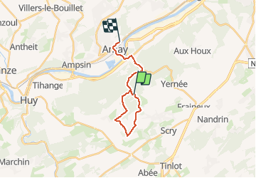

Longueur
14,9 km

Altitude max
269 m

Dénivelé positif
264 m
Km-Effort
18,7 km

Altitude min
60 m

Dénivelé négatif
352 m
Boucle
Non
Date de création :
2020-10-28 13:26:24.0
Dernière modification :
2020-10-28 15:49:24.058
2h21
Difficulté : Inconnu

Application GPS de randonnée GRATUITE
 SityTrail
IGN / Instituts géographiques
SityTrail Plus
Le monde est à vous
À propos
Randonnée Marche de 14,9 km à découvrir à Wallonie, Liège, Nandrin. Cette randonnée est proposée par thomarche.
Description
Marche. Magnifique. Varié. Longer petits ruisseaux, vues, bois, traverse hameaux, quasi rien macadam. Sublime découverte.
Localisation
Pays :
Belgique
Région :
Wallonie
Département/Province :
Liège
Commune :
Nandrin
Localité :
Villers-le-Temple
Départ:(Dec)
Départ:(UTM)
666025 ; 5599267 (31U) N.
Commentaires