


Failon (Barvaux Condroz)

thomarche
Utilisateur
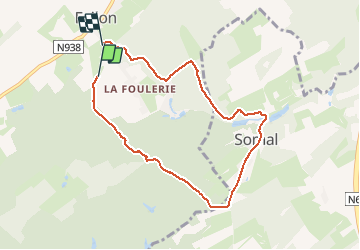

Longueur
7 km

Altitude max
315 m

Dénivelé positif
199 m
Km-Effort
9,7 km

Altitude min
228 m

Dénivelé négatif
214 m
Boucle
Non
Date de création :
2020-11-05 11:35:28.0
Dernière modification :
2020-11-05 13:42:59.081
2h07
Difficulté : Inconnu

Application GPS de randonnée GRATUITE
 SityTrail
IGN / Instituts géographiques
SityTrail Plus
Le monde est à vous
À propos
Randonnée Marche de 7 km à découvrir à Wallonie, Namur, Havelange. Cette randonnée est proposée par thomarche.
Description
Belle marche chemins,petite route près chateau Somal.
Localisation
Pays :
Belgique
Région :
Wallonie
Département/Province :
Namur
Commune :
Havelange
Localité :
Barvaux-Condroz
Départ:(Dec)
Départ:(UTM)
663155 ; 5578285 (31U) N.
Commentaires