


Molignee (Ht Le Wastia) Ruines Montaigle Ravel

thomarche
Utilisateur
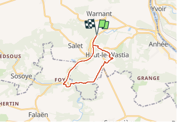

Longueur
9,2 km

Altitude max
220 m

Dénivelé positif
213 m
Km-Effort
12,1 km

Altitude min
109 m

Dénivelé négatif
213 m
Boucle
Oui
Date de création :
2020-11-08 11:58:56.0
Dernière modification :
2020-11-08 14:44:22.716
2h44
Difficulté : Inconnu

Application GPS de randonnée GRATUITE
 SityTrail
IGN / Instituts géographiques
SityTrail Plus
Le monde est à vous
À propos
Randonnée Marche de 9,2 km à découvrir à Wallonie, Namur, Anhée. Cette randonnée est proposée par thomarche.
Localisation
Pays :
Belgique
Région :
Wallonie
Département/Province :
Namur
Commune :
Anhée
Localité :
Warnant
Départ:(Dec)
Départ:(UTM)
630621 ; 5575160 (31U) N.
Commentaires