


2021-01 Rando Forêt Saint-Hubert

rando1490
Utilisateur
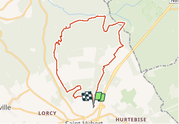

Longueur
17,3 km

Altitude max
583 m

Dénivelé positif
436 m
Km-Effort
23 km

Altitude min
408 m

Dénivelé négatif
432 m
Boucle
Oui
Date de création :
2021-01-09 08:57:04.531
Dernière modification :
2021-04-19 19:36:19.245
3h57
Difficulté : Moyen

Application GPS de randonnée GRATUITE
 SityTrail
IGN / Instituts géographiques
SityTrail Plus
Le monde est à vous
À propos
Randonnée Marche de 17,3 km à découvrir à Wallonie, Luxembourg, Saint-Hubert. Cette randonnée est proposée par rando1490.
Description
Rando covi-19 à 4 avec en partie de la neige
Localisation
Pays :
Belgique
Région :
Wallonie
Département/Province :
Luxembourg
Commune :
Saint-Hubert
Localité :
Saint-Hubert
Départ:(Dec)
Départ:(UTM)
670482 ; 5544934 (31U) N.
Commentaires