


Michel DUBOIS
Utilisateur
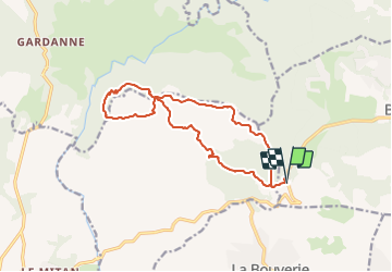

Longueur
15,5 km

Altitude max
532 m

Dénivelé positif
485 m
Km-Effort
22 km

Altitude min
249 m

Dénivelé négatif
490 m
Boucle
Oui
Date de création :
2021-02-15 15:37:02.307
Dernière modification :
2021-02-15 15:37:02.307

Application GPS de randonnée GRATUITE
 SityTrail
IGN / Instituts géographiques
SityTrail Plus
Le monde est à vous
À propos
Randonnée de 15,5 km à découvrir à Provence-Alpes-Côte d'Azur, Var, Bagnols-en-Forêt. Cette randonnée est proposée par Michel DUBOIS.
Localisation
Pays :
France
Région :
Provence-Alpes-Côte d'Azur
Département/Province :
Var
Commune :
Bagnols-en-Forêt
Localité :
Unknown
Départ:(Dec)
Départ:(UTM)
310043 ; 4821352 (32T) N.
Commentaires