


navette

whisper73
Utilisateur
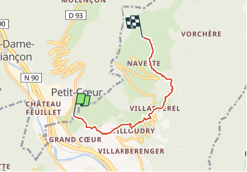

Longueur
4,4 km

Altitude max
1206 m

Dénivelé positif
686 m
Km-Effort
11,3 km

Altitude min
512 m

Dénivelé négatif
6 m
Boucle
Non
Date de création :
2021-02-27 09:30:01.229
Dernière modification :
2021-02-27 11:01:11.054
1h27
Difficulté : Moyen
30m
Difficulté : Facile

Application GPS de randonnée GRATUITE
 SityTrail
IGN / Instituts géographiques
SityTrail Plus
Le monde est à vous
À propos
Randonnée Marche de 4,4 km à découvrir à Auvergne-Rhône-Alpes, Savoie, La Léchère. Cette randonnée est proposée par whisper73.
Localisation
Pays :
France
Région :
Auvergne-Rhône-Alpes
Département/Province :
Savoie
Commune :
La Léchère
Localité :
Unknown
Départ:(Dec)
Départ:(UTM)
304126 ; 5043720 (32T) N.
Commentaires