


Hatrival

pierlan
Utilisateur
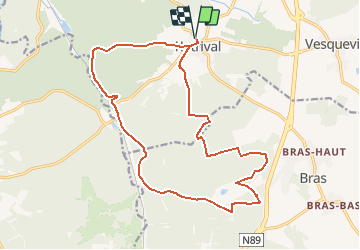

Longueur
17,8 km

Altitude max
568 m

Dénivelé positif
428 m
Km-Effort
24 km

Altitude min
355 m

Dénivelé négatif
428 m
Boucle
Oui
Date de création :
2021-02-27 16:37:17.117
Dernière modification :
2021-02-27 16:51:44.552
4h00
Difficulté : Très facile

Application GPS de randonnée GRATUITE
 SityTrail
IGN / Instituts géographiques
SityTrail Plus
Le monde est à vous
À propos
Randonnée Trail de 17,8 km à découvrir à Wallonie, Luxembourg, Saint-Hubert. Cette randonnée est proposée par pierlan.
Localisation
Pays :
Belgique
Région :
Wallonie
Département/Province :
Luxembourg
Commune :
Saint-Hubert
Localité :
Hatrival
Départ:(Dec)
Départ:(UTM)
668183 ; 5542065 (31U) N.
Commentaires