Randonnée Marche Ambérieux-en-Dombes - Amberieux en Dombes - Photo
 Thomasdanielle
Thomasdanielle

Utilisateur

© OpenStreetMap contributors
Longueur
Longueur
18,5 km
Altitude max
Altitude max
302 m
Dénivelé positif
Dénivelé positif
109 m
Km-Effort
Km-Effort  
20 km
Altitude min
Altitude min
270 m
Dénivelé négatif
Dénivelé négatif
109 m
Boucle
Boucle
Oui
Date de création :
2021-04-25 07:49:20.0
Dernière modification :
2021-04-25 14:12:23.749

(0 Avis)

Marche
Marche
4h55
Difficulté : Facile

Scannez ce code QR pour ouvrir la randonnée dans l'application SityTrail

Application GPS de randonnée GRATUITE

Logo SityTrail SityTrail

IGN / Instituts géographiques

Télécharger SityTrail sur l'App Store Télécharger SityTrail sur Google Play

Logo SityTrail SityTrail World

Le monde est à vous

Télécharger SityTrail sur l'App Store Télécharger SityTrail sur Google Play Télécharger SityTrail sur Huawei AppGallery

À propos

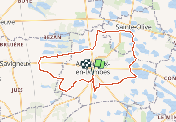
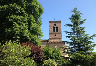
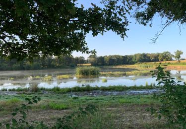
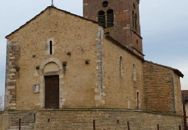
Randonnée Marche de 18,5 km à découvrir à Auvergne-Rhône-Alpes, Ain, Ambérieux-en-Dombes. Cette randonnée est proposée par Thomasdanielle.

Description

Parking  mairie et école

Profil altimétrique

Localisation

Pays :
France
Région :
Auvergne-Rhône-Alpes
Département/Province :
Ain
Commune :
Ambérieux-en-Dombes
Localité :
Unknown
Départ:(Dec)
Départ:(UTM)
647361 ; 5095289 (31T) N.

Randonnées à proximité

Randonnée A pied Monthieux - Observatoire sur l'Étang Grange Volet - Photo
A pied
PRO

A pied

Facile
Monthieux, Auvergne-Rhône-Alpes, Ain, France
7,3 km | 7,9 km-effort
1h 47min
Oui
Randonnée Marche Monthieux - Monthieux-11km-78m - Photo
Marche
ThierryJ01

Marche

Moyen
(2)
Monthieux, Auvergne-Rhône-Alpes, Ain, France
10,9 km | 11,9 km-effort
2h 39min
Oui
Randonnée Marche Savigneux - Savigneux le Fond de Juis Savigneux - Photo
Marche
jll7513

Marche

Très facile
Savigneux, Auvergne-Rhône-Alpes, Ain, France
12,7 km | 14 km-effort
3h 7min
Oui
Randonnée Marche Monthieux - Étangs Monthieux  - Photo
Marche
partner

Marche

Très facile
Monthieux, Auvergne-Rhône-Alpes, Ain, France
5,9 km | 6,3 km-effort
2h 16min
Oui
Randonnée Marche Saint-Jean-de-Thurigneux - St Jean de Thrinueux autour du Camping du Soleil de Lyon - Photo
Marche
jll7513

Marche

Facile
Saint-Jean-de-Thurigneux, Auvergne-Rhône-Alpes, Ain, France
7,1 km | 7,7 km-effort
1h 44min
Oui
Randonnée Marche Sainte-Olive - 01 - SAINTE-OLIVE - Photo
Marche
AndreLACOMBE

Marche

Très facile
Sainte-Olive, Auvergne-Rhône-Alpes, Ain, France
6,6 km | 7,1 km-effort
2h 29min
Oui
Randonnée Marche Sainte-Olive - Sainte Olive-Etang de Chardonnet-Ain - Photo
Marche
ThierryJ01

Marche

Moyen
Sainte-Olive, Auvergne-Rhône-Alpes, Ain, France
6,5 km | 7 km-effort
1h 35min
Oui
Randonnée Vélo Ambérieux-en-Dombes - Amberieux-en-Dombes - Photo
Vélo
doclocjl

Vélo

Très facile
Ambérieux-en-Dombes, Auvergne-Rhône-Alpes, Ain, France
41 km | 45 km-effort
3h 44min
Oui
Randonnée Moteur Sainte-Olive - Sainte Olive St Jean Th.Trevoux Chasselay Tata S.retour Rancé Amberieux - Photo
Moteur
BGO

Moteur

Très facile
Sainte-Olive, Auvergne-Rhône-Alpes, Ain, France
64 km | 71 km-effort
Inconnu
Oui


Fermer
Mes abonnements