Randonnée V.T.T. Dinant - Dinant-Hastière - Photo

Dinant-Hastière

 ChristianNILE
ChristianNILE

Utilisateur

© OpenStreetMap contributors
Longueur
Longueur
24 km
Altitude max
Altitude max
252 m
Dénivelé positif
Dénivelé positif
419 m
Km-Effort
Km-Effort  
30 km
Altitude min
Altitude min
89 m
Dénivelé négatif
Dénivelé négatif
420 m
Boucle
Boucle
Oui
Date de création :
2021-05-09 16:09:13.68
Dernière modification :
2021-05-09 19:05:03.813

(1 Avis)

V.T.T.
V.T.T.
2h55
Difficulté : Moyen

Scannez ce code QR pour ouvrir la randonnée dans l'application SityTrail

Application GPS de randonnée GRATUITE

Logo SityTrail SityTrail

IGN / Instituts géographiques

Télécharger SityTrail sur l'App Store Télécharger SityTrail sur Google Play

Logo SityTrail SityTrail World

Le monde est à vous

Télécharger SityTrail sur l'App Store Télécharger SityTrail sur Google Play Télécharger SityTrail sur Huawei AppGallery

À propos

Randonnée V.T.T. de 24 km à découvrir à Wallonie, Namur, Dinant. Cette randonnée est proposée par ChristianNILE.

Description

Au fil de l'eau après un début de fort dénivelé. A éviter quand il fait boueux ou lors de la saison touristique si retour sous les rochers de Freyr.

Profil altimétrique

Localisation

Pays :
Belgique
Région :
Wallonie
Département/Province :
Namur
Commune :
Dinant
Localité :
Dinant
Départ:(UTM)
636552 ; 5567194 (31U) N.

Commentaires

Veuillez vous connecter pour laisser un commentaire ou une note


Randonnées à proximité

Randonnée Marche Dinant - RB-Na-24_Anseremme - Photo
Marche
PRO

Marche

Très difficile
(14)
Dinant, Wallonie, Namur, Belgique
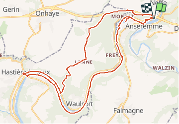
19,3 km | 26 km-effort
5h 57min
Oui
Randonnée Marche Houyet - RL-GG-20_Gendron_Dinant - Photo
Marche
PRO

Marche

Très difficile
(4)
Houyet, Wallonie, Namur, Belgique
23 km | 30 km-effort
6h 27min
Non
Randonnée Marche Dinant - Balade à Dinant - La Réserve Naturelle de Moniat - Photo
Marche
GUIDE
Desrumaux

Marche

Très facile
(1)
Dinant, Wallonie, Namur, Belgique
8,4 km | 10,9 km-effort
3h 54min
Oui
Randonnée Marche Dinant - D'Anseremme à Dinant - Photo
Marche
GUIDE
Desrumaux

Marche

Facile
(3)
Dinant, Wallonie, Namur, Belgique
8,3 km | 11,8 km-effort
2h 34min
Oui
Randonnée Marche Dinant - Balade à Bouvignes - Photo
Marche
GUIDE
Desrumaux

Marche

Facile
(3)
Dinant, Wallonie, Namur, Belgique
4,8 km | 7,2 km-effort
1h 34min
Oui
Randonnée Marche Dinant - Balade en Réserve Naturelle de Devant Bouvignes - Photo
Marche
GUIDE
Desrumaux

Marche

Très facile
(3)
Dinant, Wallonie, Namur, Belgique
4,9 km | 6,9 km-effort
1h 32min
Oui
Randonnée Marche Dinant - Dinant: autour de la Citadelle.  - Photo
Marche
godi

Marche

Facile
(4)
Dinant, Wallonie, Namur, Belgique
5,7 km | 7,5 km-effort
1h 40min
Oui
Randonnée Marche Dinant - RB-Na-24_Anseremme_via-racc - Photo
Marche
PRO

Marche

Très difficile
(4)
Dinant, Wallonie, Namur, Belgique
18,5 km | 24 km-effort
5h 29min
Oui
Randonnée Marche Dinant - DINANT ... Montagne de la Croix et l’ île d'Amour. - Photo
Marche
GerardBouche

Marche

Moyen
(1)
Dinant, Wallonie, Namur, Belgique
11,5 km | 15,5 km-effort
3h 13min
Oui


Fermer
Mes abonnements