


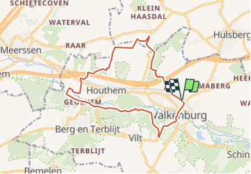
Limburg - Wandeling Langs mergel en langs dalen

gpstracks
Utilisateur

Longueur
13,8 km

Altitude max
141 m

Dénivelé positif
281 m
Km-Effort
17,5 km

Altitude min
54 m

Dénivelé négatif
279 m
Boucle
Oui
Date de création :
2014-12-10 00:00:00.0
Dernière modification :
2014-12-10 00:00:00.0
--
Difficulté : Inconnu

Application GPS de randonnée GRATUITE
 SityTrail
IGN / Instituts géographiques
SityTrail Plus
Le monde est à vous
À propos
Randonnée Marche de 13,8 km à découvrir à Limbourg, Inconnu, Valkenburg aan de Geul. Cette randonnée est proposée par gpstracks.
Description
More information on GPStracks.nl : http://www.gpstracks.nl


Localisation
Pays :
Pays-Bas
Région :
Limbourg
Département/Province :
Inconnu
Commune :
Valkenburg aan de Geul
Localité :
Unknown
Départ:(Dec)
Départ:(UTM)
699307 ; 5639073 (31U) N.
Commentaires