


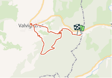
Valvignères 8km

thonyc
Utilisateur GUIDE

Longueur
7,9 km

Altitude max
325 m

Dénivelé positif
263 m
Km-Effort
11,5 km

Altitude min
133 m

Dénivelé négatif
280 m
Boucle
Non
Date de création :
2021-05-22 13:58:31.231
Dernière modification :
2021-05-22 19:51:13.429
2h22
Difficulté : Facile

Application GPS de randonnée GRATUITE
 SityTrail
IGN / Instituts géographiques
SityTrail Plus
Le monde est à vous
À propos
Randonnée Marche de 7,9 km à découvrir à Auvergne-Rhône-Alpes, Ardèche, Valvignères. Cette randonnée est proposée par thonyc.
Localisation
Pays :
France
Région :
Auvergne-Rhône-Alpes
Département/Province :
Ardèche
Commune :
Valvignères
Localité :
Unknown
Départ:(Dec)
Départ:(UTM)
627203 ; 4928261 (31T) N.
Commentaires