


Redu 10 juin 21

pierlan
Utilisateur
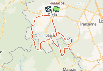

Longueur
15,9 km

Altitude max
410 m

Dénivelé positif
450 m
Km-Effort
22 km

Altitude min
258 m

Dénivelé négatif
444 m
Boucle
Oui
Date de création :
2021-06-05 15:29:43.521
Dernière modification :
2021-06-05 15:30:35.201
3h00
Difficulté : Très facile

Application GPS de randonnée GRATUITE
 SityTrail
IGN / Instituts géographiques
SityTrail Plus
Le monde est à vous
À propos
Randonnée Trail de 15,9 km à découvrir à Wallonie, Luxembourg, Libin. Cette randonnée est proposée par pierlan.
Localisation
Pays :
Belgique
Région :
Wallonie
Département/Province :
Luxembourg
Commune :
Libin
Localité :
Unknown
Départ:(Dec)
Départ:(UTM)
654771 ; 5541658 (31U) N.
Commentaires