Randonnée V.T.T. Ponthoile - ST-VALERY ... par la très belle chapelle de Hamelet.  - Photo

ST-VALERY ... par la très belle chapelle de Hamelet.

 GerardBouche
GerardBouche

Utilisateur

© OpenStreetMap contributors
Longueur
Longueur
18,9 km
Altitude max
Altitude max
8 m
Dénivelé positif
Dénivelé positif
53 m
Km-Effort
Km-Effort  
19,6 km
Altitude min
Altitude min
0 m
Dénivelé négatif
Dénivelé négatif
53 m
Boucle
Boucle
Oui
Date de création :
2021-07-09 12:33:17.655
Dernière modification :
2021-07-17 06:33:59.27

(0 Avis)

V.T.T.
V.T.T.
1h49
Difficulté : Très facile

Scannez ce code QR pour ouvrir la randonnée dans l'application SityTrail

Application GPS de randonnée GRATUITE

Logo SityTrail SityTrail

IGN / Instituts géographiques

Télécharger SityTrail sur l'App Store Télécharger SityTrail sur Google Play

Logo SityTrail SityTrail World

Le monde est à vous

Télécharger SityTrail sur l'App Store Télécharger SityTrail sur Google Play Télécharger SityTrail sur Huawei AppGallery

À propos

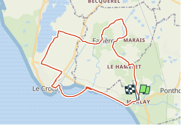
Randonnée V.T.T. de 18,9 km à découvrir à Hauts-de-France, Somme, Ponthoile. Cette randonnée est proposée par GerardBouche.

Description

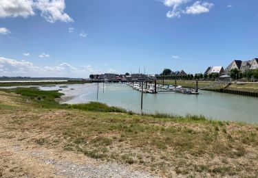
Au départ de Morlay par la chapelle du Hamelet (XVI ème siècle) le village de Favières (Le Marais, le Moulin à eau) et le hameau de Mayoc.
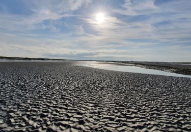
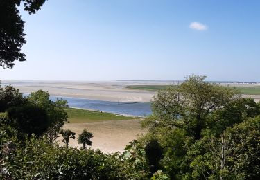
Rejoindre la cité des Crotellois (Le Crotoy) , et poursuivre par sa promenade " Manessier " ( /-2 km) avec son point de vue sur le port, sa baie et ses prés salés.


Profil altimétrique

Photos

Localisation

Pays :
France
Région :
Hauts-de-France
Département/Province :
Somme
Commune :
Ponthoile
Localité :
Unknown
Départ:(UTM)
406284 ; 5562958 (31U) N.

Randonnées à proximité

Randonnée Marche Saint-Valery-sur-Somme - Balade à Saint-Valéry-sur-Somme - Photo
Marche
GUIDE
Desrumaux

Marche

Facile
(4)
Saint-Valery-sur-Somme, Hauts-de-France, Somme, France
10,4 km | 12,2 km-effort
2h 41min
Oui
Randonnée Marche Saint-Valery-sur-Somme - Balade à Saint-Valery sur Somme - Photo
Marche
tracegps

Marche

Moyen
(3)
Saint-Valery-sur-Somme, Hauts-de-France, Somme, France
7,1 km | 8,6 km-effort
2h 19min
Oui
Randonnée Marche Favières - Circuit de Morlay - Photo
Marche
tracegps

Marche

Difficile
(1)
Favières, Hauts-de-France, Somme, France
12,4 km | 12,8 km-effort
4h 0min
Oui
Randonnée Marche Saint-Valery-sur-Somme - Traversée Baie de Somme - St Valery - Le Crotoy - Photo
Marche
GUIDE
R@ph

Marche

Moyen
Saint-Valery-sur-Somme, Hauts-de-France, Somme, France
8,5 km | 8,8 km-effort
2h 0min
Non
Randonnée V.T.T. Saint-Valery-sur-Somme - Gravelot Baie de sommes - Photo
V.T.T.
Jeanlouisbray

V.T.T.

Facile
(1)
Saint-Valery-sur-Somme, Hauts-de-France, Somme, France
44 km | 47 km-effort
4h 56min
Oui
Randonnée Vélo Le Crotoy - Crotoy - Marquenterre - Photo
Vélo
jacques.moulin@hotmail.com

Vélo

Moyen
(1)
Le Crotoy, Hauts-de-France, Somme, France
18,3 km | 19,2 km-effort
1h 8min
Oui
Randonnée Marche Le Crotoy - traversée baie somme et train - Photo
Marche
lefrancm

Marche

Très facile
(1)
Le Crotoy, Hauts-de-France, Somme, France
24 km | 25 km-effort
6h 58min
Non
Randonnée Marche Saint-Valery-sur-Somme - Baie de Somme - Photo
Marche
Greg813

Marche

Difficile
Saint-Valery-sur-Somme, Hauts-de-France, Somme, France
25 km | 27 km-effort
5h 26min
Oui
Randonnée Marche Le Crotoy - Port du crotoy - port de St Valéry sur somme par GR - Photo
Marche
ash

Marche

Très facile
(1)
Le Crotoy, Hauts-de-France, Somme, France
12,3 km | 12,7 km-effort
2h 40min
Non


Fermer
Mes abonnements