


Loungat - L'Uby

MarcLEBARON
Utilisateur
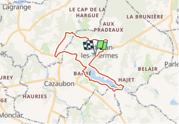

Longueur
15 km

Altitude max
159 m

Dénivelé positif
209 m
Km-Effort
17,8 km

Altitude min
99 m

Dénivelé négatif
209 m
Boucle
Oui
Date de création :
2021-07-23 13:31:58.531
Dernière modification :
2021-07-23 16:46:18.989
3h05
Difficulté : Facile

Application GPS de randonnée GRATUITE
 SityTrail
IGN / Instituts géographiques
SityTrail Plus
Le monde est à vous
À propos
Randonnée Marche de 15 km à découvrir à Occitanie, Gers, Cazaubon. Cette randonnée est proposée par MarcLEBARON.
Localisation
Pays :
France
Région :
Occitanie
Département/Province :
Gers
Commune :
Cazaubon
Localité :
Unknown
Départ:(Dec)
Départ:(UTM)
736974 ; 4870382 (30T) N.
Commentaires