


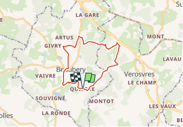
Quierre Nord bis

jeanboulay
Utilisateur

Longueur
12,6 km

Altitude max
476 m

Dénivelé positif
396 m
Km-Effort
17,9 km

Altitude min
327 m

Dénivelé négatif
391 m
Boucle
Oui
Date de création :
2021-08-16 20:52:58.881
Dernière modification :
2021-08-16 20:54:03.287
1h14
Difficulté : Facile

Application GPS de randonnée GRATUITE
 SityTrail
IGN / Instituts géographiques
SityTrail Plus
Le monde est à vous
À propos
Randonnée V.T.T. de 12,6 km à découvrir à Bourgogne-Franche-Comté, Saône-et-Loire, Beaubery. Cette randonnée est proposée par jeanboulay.
Localisation
Pays :
France
Région :
Bourgogne-Franche-Comté
Département/Province :
Saône-et-Loire
Commune :
Beaubery
Localité :
Unknown
Départ:(Dec)
Départ:(UTM)
608084 ; 5138767 (31T) N.
Commentaires