


Quierre nord 6

jeanboulay
Utilisateur
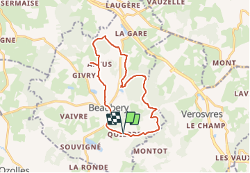

Longueur
13,8 km

Altitude max
497 m

Dénivelé positif
343 m
Km-Effort
18,4 km

Altitude min
344 m

Dénivelé négatif
341 m
Boucle
Oui
Date de création :
2021-08-20 07:52:14.962
Dernière modification :
2021-08-20 10:51:33.984
1h49
Difficulté : Facile

Application GPS de randonnée GRATUITE
 SityTrail
IGN / Instituts géographiques
SityTrail Plus
Le monde est à vous
À propos
Randonnée V.T.T. de 13,8 km à découvrir à Bourgogne-Franche-Comté, Saône-et-Loire, Beaubery. Cette randonnée est proposée par jeanboulay.
Localisation
Pays :
France
Région :
Bourgogne-Franche-Comté
Département/Province :
Saône-et-Loire
Commune :
Beaubery
Localité :
Unknown
Départ:(Dec)
Départ:(UTM)
608012 ; 5138785 (31T) N.
Commentaires