


brochon grevrey

LUCIE2016
Utilisateur
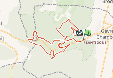

Longueur
11,3 km

Altitude max
472 m

Dénivelé positif
510 m
Km-Effort
18,1 km

Altitude min
298 m

Dénivelé négatif
521 m
Boucle
Oui
Date de création :
2021-09-11 07:39:14.632
Dernière modification :
2021-09-11 13:29:05.371
5h17
Difficulté : Difficile

Application GPS de randonnée GRATUITE
 SityTrail
IGN / Instituts géographiques
SityTrail Plus
Le monde est à vous
À propos
Randonnée Marche de 11,3 km à découvrir à Bourgogne-Franche-Comté, Côte-d'Or, Gevrey-Chambertin. Cette randonnée est proposée par LUCIE2016.
Localisation
Pays :
France
Région :
Bourgogne-Franche-Comté
Département/Province :
Côte-d'Or
Commune :
Gevrey-Chambertin
Localité :
Unknown
Départ:(Dec)
Départ:(UTM)
648102 ; 5231908 (31T) N.
Commentaires