![](/images/other/stat-length.png)
![Randonnée Marche Mas-de-Londres - tour du Pic St Loup - Photo](https://media.geolcdn.com/t/1900/400/ext.pjpeg?maxdim=2&url=https%3A%2F%2Fmedia.geolcdn.com%2Ff%2F454f4453-86c9-48a0-8b22-c42a379f5d4f.jpg)
tour du Pic St Loup
ajd26
Utilisateur
![Longueur](/images/other/stat-length.png)
Longueur
14,8 km
![Altitude max](https://static1.geolcdn.com/siteimages/upload/files/1508320355ic_sort_altitude_max_24dp.png)
Altitude max
649 m
![Dénivelé positif](https://static1.geolcdn.com/siteimages/upload/files/1508320355ic_sort_den_pos_24dp.png)
Dénivelé positif
578 m
![Km-Effort](/images/other/stat-length.png)
Km-Effort
23 km
![Altitude min](https://static1.geolcdn.com/siteimages/upload/files/1508320355ic_sort_altitude_min_24dp.png)
Altitude min
207 m
![Dénivelé négatif](https://static1.geolcdn.com/siteimages/upload/files/1508320355ic_sort_den_neg_24dp.png)
Dénivelé négatif
578 m
![Boucle](https://static1.geolcdn.com/siteimages/upload/files/16400158638029165_repeat_loop_refresh_sync_direction_icon.png)
Boucle
Oui
Date de création :
2021-10-16 08:00:20.0
Dernière modification :
2021-10-22 07:28:42.327
![Marche](https://static1.geolcdn.com/sitytour/trail-icons/101.png)
4h30
Difficulté : Moyen
![Scannez ce code QR pour ouvrir la randonnée dans l'application SityTrail](https://capi.geolives.com/qq0zvz2zws4bq2lad0pu/sitytour/trails/2972073/qr.png?size=200)
Application GPS de randonnée GRATUITE
À propos
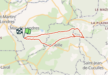
Randonnée Marche de 14,8 km à découvrir à Occitanie, Hérault, Mas-de-Londres. Cette randonnée est proposée par ajd26.
Description
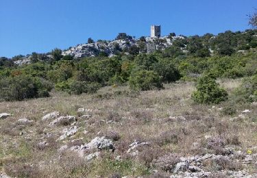
depart dans la garrigue, accès UNIQUEMENT par la D986 (route en sens unique)
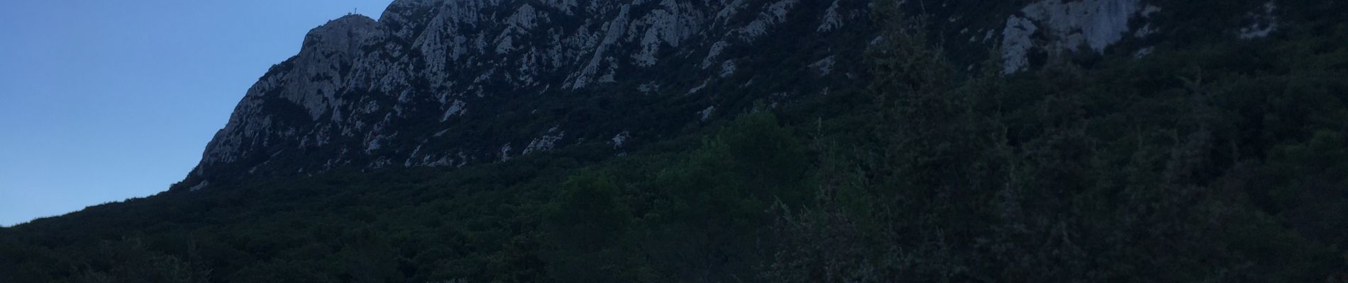
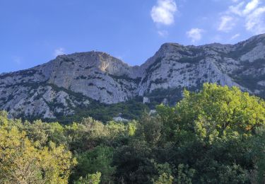
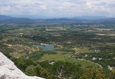
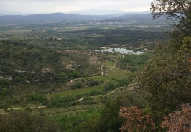
on contourne le Pic coté nord au pied de la falaise (très ombragé) et ascension par la voie classique
Localisation
Pays :
France
Région :
Occitanie
Département/Province :
Hérault
Commune :
Mas-de-Londres
Localité :
Unknown
Départ:(Dec)
Départ:(UTM)
560793 ; 4847248 (31T) N.
Commentaires
Randonnées à proximité
![Randonnée Marche Viols-en-Laval - Fontaine Terou - Photo](https://media.geolcdn.com/t/375/260/ext.jpg?maxdim=2&url=https%3A%2F%2Fmedia.geolcdn.com%2Ff%2F893d4ed9-6474-41c2-a5cc-5fad7e67044e.jpg)
![Marche Marche](https://static1.geolcdn.com/sitytour/trail-icons/101.png)
Fontaine Terou
Marche
Moyen
(1)
Viols-en-Laval,
Occitanie,
Hérault,
France
![](/images/other/stat-length.png)
12,5 km | 14,9 km-effort
4h 5min
![](https://static1.geolcdn.com/siteimages/upload/files/16400158638029165_repeat_loop_refresh_sync_direction_icon.png)
Oui
![Randonnée Marche Saint-Martin-de-Londres - l'ouradou - Photo](https://media.geolcdn.com/t/375/260/ext.jpg?maxdim=2&url=https%3A%2F%2Fservices.sitytrail.com%2FGeolivesWS%2FDownloadMedia.ashx%3FTrailID%3D860187%26Media%3D20171107114231.jpg)
![Marche Marche](https://static1.geolcdn.com/sitytour/trail-icons/101.png)
l'ouradou
Marche
Moyen
(1)
Saint-Martin-de-Londres,
Occitanie,
Hérault,
France
![](/images/other/stat-length.png)
14,4 km | 19,2 km-effort
3h 39min
![](https://static1.geolcdn.com/siteimages/upload/files/16400158638029165_repeat_loop_refresh_sync_direction_icon.png)
Oui
![Randonnée Marche Cazevieille - le tour du pic st loup - Photo](https://media.geolcdn.com/t/375/260/ext.jpg?maxdim=2&url=https%3A%2F%2Fservices.sitytrail.com%2FGeolivesWS%2FDownloadMedia.ashx%3FTrailID%3D564155%26Media%3Dfix__20160505154449.jpg)
![Marche Marche](https://static1.geolcdn.com/sitytour/trail-icons/101.png)
le tour du pic st loup
Marche
Moyen
(1)
Cazevieille,
Occitanie,
Hérault,
France
![](/images/other/stat-length.png)
11,4 km | 19,8 km-effort
4h 34min
![](https://static1.geolcdn.com/siteimages/upload/files/16400158638029165_repeat_loop_refresh_sync_direction_icon.png)
Oui
![Randonnée Marche Mas-de-Londres - face nord pic Saint Loup - Photo](https://media.geolcdn.com/t/375/260/ext.jpg?maxdim=2&url=https%3A%2F%2Fmedia.geolcdn.com%2Ff%2Fd1059764-52a0-4b94-ba59-729039d80717.jpg)
![Marche Marche](https://static1.geolcdn.com/sitytour/trail-icons/101.png)
face nord pic Saint Loup
Marche
Difficile
Mas-de-Londres,
Occitanie,
Hérault,
France
![](/images/other/stat-length.png)
3,8 km | 9,4 km-effort
2h 0min
![](https://static1.geolcdn.com/siteimages/upload/files/16400158638029165_repeat_loop_refresh_sync_direction_icon.png)
Oui
![Randonnée Marche Mas-de-Londres - LL34-Pic St Loup par arête ouest - Photo](https://media.geolcdn.com/t/375/260/ext.jpg?maxdim=2&url=https%3A%2F%2Fstatic1.geolcdn.com%2Fsiteimages%2Fupload%2Ffiles%2F1553511878bg_sport_marche.png)
![Marche Marche](https://static1.geolcdn.com/sitytour/trail-icons/101.png)
LL34-Pic St Loup par arête ouest
Marche
Moyen
(4)
Mas-de-Londres,
Occitanie,
Hérault,
France
![](/images/other/stat-length.png)
10,5 km | 17,9 km-effort
5h 10min
![](https://static1.geolcdn.com/siteimages/upload/files/16400158638029165_repeat_loop_refresh_sync_direction_icon.png)
Oui
![Randonnée Marche Cazevieille - cazevieille-pic st loup-lac fe la jasse - Photo](https://media.geolcdn.com/t/375/260/ext.jpg?maxdim=2&url=https%3A%2F%2Fservices.sitytrail.com%2FGeolivesWS%2FDownloadMedia.ashx%3FTrailID%3D579300%26Media%3Dfix__20160604134108.jpg)
![Marche Marche](https://static1.geolcdn.com/sitytour/trail-icons/101.png)
cazevieille-pic st loup-lac fe la jasse
Marche
Difficile
(2)
Cazevieille,
Occitanie,
Hérault,
France
![](/images/other/stat-length.png)
14,7 km | 23 km-effort
5h 21min
![](https://static1.geolcdn.com/siteimages/upload/files/16400158638029165_repeat_loop_refresh_sync_direction_icon.png)
Oui
![Randonnée Marche nordique Cazevieille - cazevieille + lac de la jasse - Photo](https://media.geolcdn.com/t/375/260/ext.jpg?maxdim=2&url=https%3A%2F%2Fservices.sitytrail.com%2FGeolivesWS%2FDownloadMedia.ashx%3FTrailID%3D565622%26Media%3Dfix__20160508095919.jpg)
![Marche nordique Marche nordique](https://static1.geolcdn.com/sitytour/trail-icons/102.png)
cazevieille + lac de la jasse
Marche nordique
Moyen
(1)
Cazevieille,
Occitanie,
Hérault,
France
![](/images/other/stat-length.png)
9,5 km | 13,6 km-effort
2h 32min
![](https://static1.geolcdn.com/siteimages/upload/files/16400158638029165_repeat_loop_refresh_sync_direction_icon.png)
Oui
![Randonnée Marche Viols-en-Laval - Viols-en-Laval - Cazarils - Montagne de Labat - Paillas - Photo](https://media.geolcdn.com/t/375/260/ext.jpg?maxdim=2&url=https%3A%2F%2Fstatic1.geolcdn.com%2Fsiteimages%2Fupload%2Ffiles%2F1553511878bg_sport_marche.png)
![Marche Marche](https://static1.geolcdn.com/sitytour/trail-icons/101.png)
Viols-en-Laval - Cazarils - Montagne de Labat - Paillas
Marche
Moyen
(1)
Viols-en-Laval,
Occitanie,
Hérault,
France
![](/images/other/stat-length.png)
15,7 km | 19,2 km-effort
4h 8min
![](https://static1.geolcdn.com/siteimages/upload/files/16400158638029165_repeat_loop_refresh_sync_direction_icon.png)
Oui
![Randonnée Marche Notre-Dame-de-Londres - Ravin des Arc 01 - Photo](https://media.geolcdn.com/t/375/260/ext.jpg?maxdim=2&url=https%3A%2F%2Fstatic1.geolcdn.com%2Fsiteimages%2Fupload%2Ffiles%2F1553511878bg_sport_marche.png)
![Marche Marche](https://static1.geolcdn.com/sitytour/trail-icons/101.png)
Ravin des Arc 01
Marche
Moyen
(3)
Notre-Dame-de-Londres,
Occitanie,
Hérault,
France
![](/images/other/stat-length.png)
5,9 km | 8,6 km-effort
1h 53min
![](https://static1.geolcdn.com/siteimages/upload/files/16400158638029165_repeat_loop_refresh_sync_direction_icon.png)
Oui