


Tour de La Gacilly

eric.deniau
Utilisateur
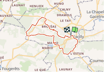

Longueur
15,5 km

Altitude max
100 m

Dénivelé positif
285 m
Km-Effort
19,3 km

Altitude min
3 m

Dénivelé négatif
287 m
Boucle
Oui
Date de création :
2021-10-17 07:37:52.0
Dernière modification :
2021-10-17 12:35:18.213
3h45
Difficulté : Très difficile

Application GPS de randonnée GRATUITE
 SityTrail
IGN / Instituts géographiques
SityTrail Plus
Le monde est à vous
À propos
Randonnée Marche de 15,5 km à découvrir à Bretagne, Morbihan, La Gacilly. Cette randonnée est proposée par eric.deniau.
Localisation
Pays :
France
Région :
Bretagne
Département/Province :
Morbihan
Commune :
La Gacilly
Localité :
La Gacilly
Départ:(Dec)
Départ:(UTM)
564644 ; 5290651 (30T) N.
Commentaires