


vignot 17 /10/21

jerome-dupont@laposte.net
Utilisateur
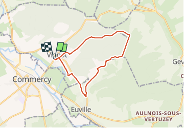

Longueur
11,7 km

Altitude max
384 m

Dénivelé positif
190 m
Km-Effort
14,2 km

Altitude min
227 m

Dénivelé négatif
191 m
Boucle
Oui
Date de création :
2021-10-17 12:45:18.323
Dernière modification :
2021-10-17 15:09:23.407
2h23
Difficulté : Très difficile

Application GPS de randonnée GRATUITE
 SityTrail
IGN / Instituts géographiques
SityTrail Plus
Le monde est à vous
À propos
Randonnée Marche de 11,7 km à découvrir à Grand Est, Meuse, Vignot. Cette randonnée est proposée par jerome-dupont@laposte.net.
Description
randonnée rapide
Localisation
Pays :
France
Région :
Grand Est
Département/Province :
Meuse
Commune :
Vignot
Localité :
Unknown
Départ:(Dec)
Départ:(UTM)
691570 ; 5405439 (31U) N.
Commentaires