


St Maurice d'Ardèche 7km

thonyc
Utilisateur GUIDE
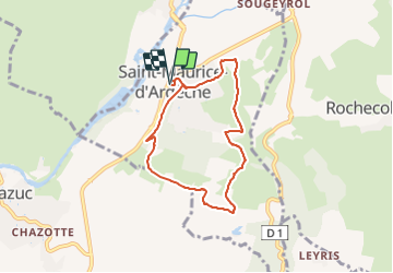

Longueur
6,7 km

Altitude max
227 m

Dénivelé positif
159 m
Km-Effort
8,8 km

Altitude min
144 m

Dénivelé négatif
158 m
Boucle
Oui
Date de création :
2021-11-22 19:14:35.748
Dernière modification :
2021-11-22 19:37:39.106
2h30
Difficulté : Facile

Application GPS de randonnée GRATUITE
 SityTrail
IGN / Instituts géographiques
SityTrail Plus
Le monde est à vous
À propos
Randonnée Marche de 6,7 km à découvrir à Auvergne-Rhône-Alpes, Ardèche, Saint-Maurice-d'Ardèche. Cette randonnée est proposée par thonyc.
Localisation
Pays :
France
Région :
Auvergne-Rhône-Alpes
Département/Province :
Ardèche
Commune :
Saint-Maurice-d'Ardèche
Localité :
Unknown
Départ:(Dec)
Départ:(UTM)
611195 ; 4930746 (31T) N.
Commentaires