


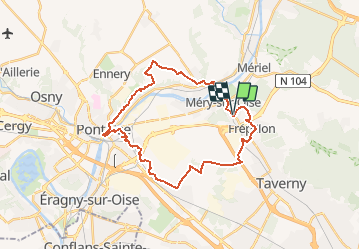
MERY SUR OISE EN BOUCLE PAR L'ABBAYE DE MAUBUISSON

NUITEVEN
Utilisateur

Longueur
28 km

Altitude max
102 m

Dénivelé positif
331 m
Km-Effort
32 km

Altitude min
18 m

Dénivelé négatif
329 m
Boucle
Oui
Date de création :
2014-12-24 00:00:00.0
Dernière modification :
2014-12-24 00:00:00.0
6h57
Difficulté : Facile

Application GPS de randonnée GRATUITE
 SityTrail
IGN / Instituts géographiques
SityTrail Plus
Le monde est à vous
À propos
Randonnée Marche de 28 km à découvrir à Île-de-France, Val-d'Oise, Méry-sur-Oise. Cette randonnée est proposée par NUITEVEN.
Localisation
Pays :
France
Région :
Île-de-France
Département/Province :
Val-d'Oise
Commune :
Méry-sur-Oise
Localité :
Unknown
Départ:(Dec)
Départ:(UTM)
440859 ; 5434183 (31U) N.
Commentaires