


Philippe Eric

Tommy Eric
Utilisateur
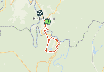

Longueur
8,7 km

Altitude max
358 m

Dénivelé positif
252 m
Km-Effort
12,1 km

Altitude min
269 m

Dénivelé négatif
245 m
Boucle
Non
Date de création :
2021-12-21 10:30:33.372
Dernière modification :
2021-12-21 13:54:17.139
3h23
Difficulté : Difficile

Application GPS de randonnée GRATUITE
 SityTrail
IGN / Instituts géographiques
SityTrail Plus
Le monde est à vous
À propos
Randonnée Marche de 8,7 km à découvrir à Wallonie, Luxembourg, Herbeumont. Cette randonnée est proposée par Tommy Eric.
Description
Rando Belge
Localisation
Pays :
Belgique
Région :
Wallonie
Département/Province :
Luxembourg
Commune :
Herbeumont
Localité :
Unknown
Départ:(Dec)
Départ:(UTM)
661114 ; 5515901 (31U) N.
Commentaires