Randonnée Marche Gaujac - gaujac - Photo
 mesrandos
mesrandos

Utilisateur

© OpenStreetMap contributors
Longueur
Longueur
10,5 km
Altitude max
Altitude max
280 m
Dénivelé positif
Dénivelé positif
195 m
Km-Effort
Km-Effort  
13,1 km
Altitude min
Altitude min
121 m
Dénivelé négatif
Dénivelé négatif
200 m
Boucle
Boucle
Non
Date de création :
2014-12-10 00:00:00.0
Dernière modification :
2014-12-10 00:00:00.0

(1 Avis)

Marche
Marche
2h56
Difficulté : Facile

Scannez ce code QR pour ouvrir la randonnée dans l'application SityTrail

Application GPS de randonnée GRATUITE

Logo SityTrail SityTrail

IGN / Instituts géographiques

Télécharger SityTrail sur l'App Store Télécharger SityTrail sur Google Play

Logo SityTrail SityTrail World

Le monde est à vous

Télécharger SityTrail sur l'App Store Télécharger SityTrail sur Google Play Télécharger SityTrail sur Huawei AppGallery

À propos

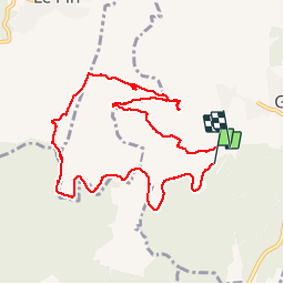
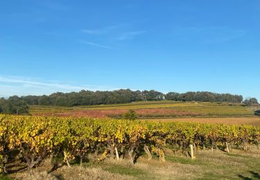
Randonnée Marche de 10,5 km à découvrir à Occitanie, Gard, Gaujac. Cette randonnée est proposée par mesrandos.
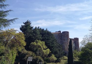
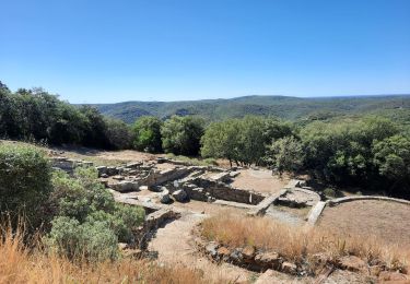
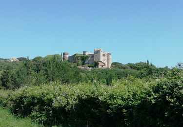
Description

opidum

Profil altimétrique

Localisation

Pays :
France
Région :
Occitanie
Département/Province :
Gard
Commune :
Gaujac
Localité :
Unknown
Départ:(Dec)
Départ:(UTM)
625305 ; 4881061 (31T) N.

Commentaires

Veuillez vous connecter pour laisser un commentaire ou une note


A partir de l'oppidium il vaut mieux redescendre par la route normale. Le parcours tracé à partir de ce site débouche sur un ruisseau asséché pierreux difficile à franchir.


Randonnées à proximité

Randonnée Marche Pouzilhac - Le sentier botanique - Pouzilhac - Photo
Marche
tracegps

Marche

Difficile
(4)
Pouzilhac, Occitanie, Gard, France
11,3 km | 14 km-effort
3h 30min
Oui
Randonnée Marche La Capelle-et-Masmolène - Masmolène et l'étang de la Capelle - Photo
Marche
jesusmarieclaire

Marche

Très facile
(1)
La Capelle-et-Masmolène, Occitanie, Gard, France
14,4 km | 16,8 km-effort
3h 37min
Non
Randonnée Marche Tresques - Autour de Tresques - Photo
Marche
tracegps

Marche

Moyen
(1)
Tresques, Occitanie, Gard, France
4,9 km | 5,6 km-effort
2h 0min
Oui
Randonnée Marche La Capelle-et-Masmolène - La Capelle-et-Masmolène - Photo
Marche
Gegetop

Marche

Facile
La Capelle-et-Masmolène, Occitanie, Gard, France
7,7 km | 9,1 km-effort
2h 8min
Oui
Randonnée Marche Cavillargues - Cavillargues  - Photo
Marche
GUIDE
Roger Philippe Wallez

Marche

Très difficile
Cavillargues, Occitanie, Gard, France
22 km | 27 km-effort
7h 2min
Oui
Randonnée Marche La Capelle-et-Masmolène - la Capelle Masmolène - Photo
Marche
GUIDE
nadinebondoux

Marche

Moyen
La Capelle-et-Masmolène, Occitanie, Gard, France
16,8 km | 21 km-effort
5h 45min
Oui
Randonnée Marche Gaujac - Gaujac 160323 - Photo
Marche
fario

Marche

Difficile
Gaujac, Occitanie, Gard, France
11 km | 14,3 km-effort
3h 15min
Oui
Randonnée Marche Le Pin - Le pin , la Garbie et oppidum - Photo
Marche
jcguew

Marche

Moyen
Le Pin, Occitanie, Gard, France
6,3 km | 8,3 km-effort
2h 42min
Non
Randonnée V.T.T. La Capelle-et-Masmolène - 30-vtt-lacapelle-St-Siffret-25km-230m-juin21 - Photo
V.T.T.
SyMA

V.T.T.

Moyen
La Capelle-et-Masmolène, Occitanie, Gard, France
25 km | 28 km-effort
2h 41min
Oui


Fermer
Mes abonnements