![](/images/other/stat-length.png)
![Randonnée Marche Offlanges - Offlange_Hermitage_Moissey 18km - Photo](https://media.geolcdn.com/t/1900/400/ext.pjpeg?maxdim=2&url=https%3A%2F%2Fservices.sitytrail.com%2FGeolivesWS%2FDownloadMedia.ashx%3FTrailID%3D305458%26Media%3Dfix__20140525154041.jpg)
Offlange_Hermitage_Moissey 18km
cmike39
Utilisateur
![Longueur](/images/other/stat-length.png)
Longueur
17,9 km
![Altitude max](https://static1.geolcdn.com/siteimages/upload/files/1508320355ic_sort_altitude_max_24dp.png)
Altitude max
384 m
![Dénivelé positif](https://static1.geolcdn.com/siteimages/upload/files/1508320355ic_sort_den_pos_24dp.png)
Dénivelé positif
364 m
![Km-Effort](/images/other/stat-length.png)
Km-Effort
23 km
![Altitude min](https://static1.geolcdn.com/siteimages/upload/files/1508320355ic_sort_altitude_min_24dp.png)
Altitude min
219 m
![Dénivelé négatif](https://static1.geolcdn.com/siteimages/upload/files/1508320355ic_sort_den_neg_24dp.png)
Dénivelé négatif
363 m
![Boucle](https://static1.geolcdn.com/siteimages/upload/files/16400158638029165_repeat_loop_refresh_sync_direction_icon.png)
Boucle
Oui
Date de création :
2014-12-10 00:00:00.0
Dernière modification :
2014-12-10 00:00:00.0
![Marche](https://static1.geolcdn.com/sitytour/trail-icons/101.png)
4h51
Difficulté : Moyen
![Scannez ce code QR pour ouvrir la randonnée dans l'application SityTrail](https://capi.geolives.com/qq0zvz2zws4bq2lad0pu/sitytour/trails/305458/qr.png?size=200)
Application GPS de randonnée GRATUITE
À propos
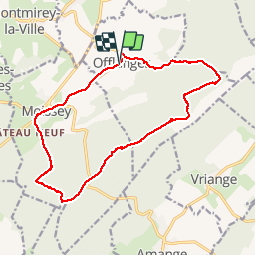
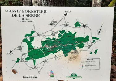
Randonnée Marche de 17,9 km à découvrir à Bourgogne-Franche-Comté, Jura, Offlanges. Cette randonnée est proposée par cmike39.
Description
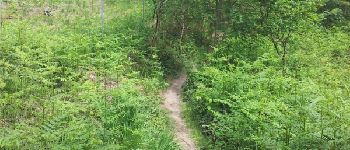
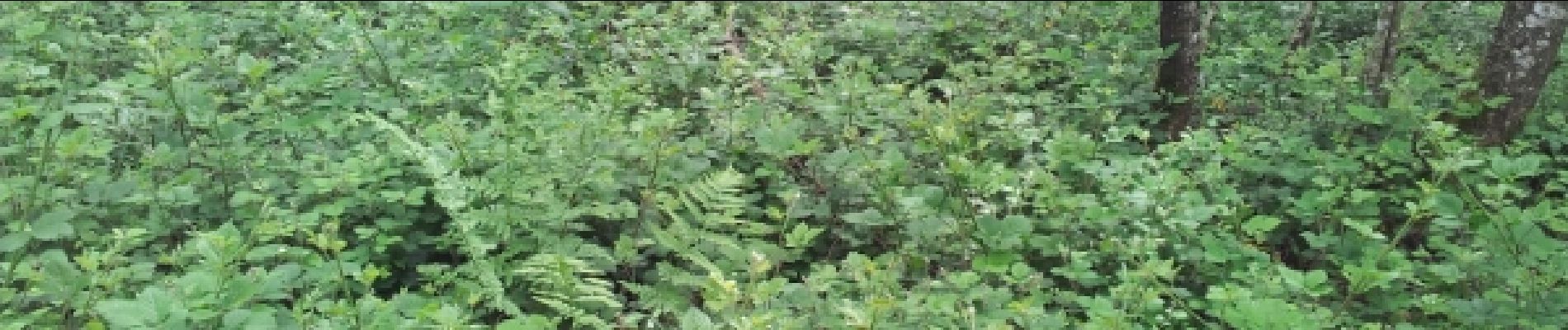
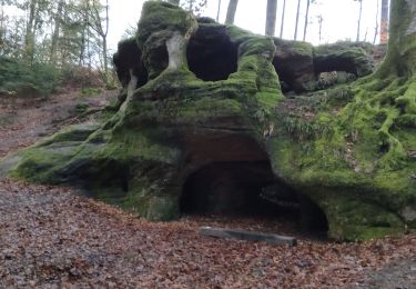
Randonnée FRA. Chemin dans le Ruisseau des Gorges probablement impraticable en période humide si le débit est important.
Localisation
Pays :
France
Région :
Bourgogne-Franche-Comté
Département/Province :
Jura
Commune :
Offlanges
Localité :
Unknown
Départ:(Dec)
Départ:(UTM)
693099 ; 5231370 (31T) N.
Commentaires
Randonnées à proximité
![Randonnée Marche nordique Vriange - Vriange - La Serre - Photo](https://media.geolcdn.com/t/375/260/ext.jpg?maxdim=2&url=https%3A%2F%2Fservices.sitytrail.com%2FGeolivesWS%2FDownloadMedia.ashx%3FTrailID%3D215897%26Media%3Dfix__20130822171149.jpg)
![Marche nordique Marche nordique](https://static1.geolcdn.com/sitytour/trail-icons/102.png)
Vriange - La Serre
Marche nordique
Difficile
(1)
Vriange,
Bourgogne-Franche-Comté,
Jura,
France
![](/images/other/stat-length.png)
8,5 km | 11,4 km-effort
1h 47min
![](https://static1.geolcdn.com/siteimages/upload/files/16400158638029165_repeat_loop_refresh_sync_direction_icon.png)
Oui
![Randonnée Marche Amange - Amange 20171009 - Photo](https://media.geolcdn.com/t/375/260/ext.jpg?maxdim=2&url=https%3A%2F%2Fstatic1.geolcdn.com%2Fsiteimages%2Fupload%2Ffiles%2F1553511878bg_sport_marche.png)
![Marche Marche](https://static1.geolcdn.com/sitytour/trail-icons/101.png)
Amange 20171009
Marche
Très facile
(1)
Amange,
Bourgogne-Franche-Comté,
Jura,
France
![](/images/other/stat-length.png)
10 km | 13,3 km-effort
2h 45min
![](https://static1.geolcdn.com/siteimages/upload/files/16400158638029165_repeat_loop_refresh_sync_direction_icon.png)
Oui
![Randonnée Marche Vriange - Le massif de la Serre. - Photo](https://media.geolcdn.com/t/375/260/ext.jpg?maxdim=2&url=https%3A%2F%2Fmedia.geolcdn.com%2Ff%2F2556d62c-7072-4944-b1e9-45e09ff6cd79.jpg)
![Marche Marche](https://static1.geolcdn.com/sitytour/trail-icons/101.png)
Le massif de la Serre.
Marche
Difficile
Vriange,
Bourgogne-Franche-Comté,
Jura,
France
![](/images/other/stat-length.png)
13,3 km | 19 km-effort
5h 46min
![](https://static1.geolcdn.com/siteimages/upload/files/16400158638029165_repeat_loop_refresh_sync_direction_icon.png)
Oui
![Randonnée Marche Menotey - Menotey 6.1 km 20230107 - Photo](https://media.geolcdn.com/t/375/260/ext.jpg?maxdim=2&url=https%3A%2F%2Fmedia.geolcdn.com%2Ff%2Fb0dcaba6-2582-4de9-a721-24859ee6865e.jpg)
![Marche Marche](https://static1.geolcdn.com/sitytour/trail-icons/101.png)
Menotey 6.1 km 20230107
Marche
Moyen
Menotey,
Bourgogne-Franche-Comté,
Jura,
France
![](/images/other/stat-length.png)
6,4 km | 8 km-effort
1h 29min
![](https://static1.geolcdn.com/siteimages/upload/files/16400158638029165_repeat_loop_refresh_sync_direction_icon.png)
Oui
![Randonnée Marche Menotey - Menotey 6.1 km 20230107 - Photo](https://media.geolcdn.com/t/375/260/ext.jpg?maxdim=2&url=https%3A%2F%2Fmedia.geolcdn.com%2Ff%2F9d6bc004-c494-40b4-a3db-502b478c6648.jpg)
![Marche Marche](https://static1.geolcdn.com/sitytour/trail-icons/101.png)
Menotey 6.1 km 20230107
Marche
Moyen
Menotey,
Bourgogne-Franche-Comté,
Jura,
France
![](/images/other/stat-length.png)
6,4 km | 8 km-effort
1h 29min
![](https://static1.geolcdn.com/siteimages/upload/files/16400158638029165_repeat_loop_refresh_sync_direction_icon.png)
Oui
![Randonnée Marche Moissey - MOISSEY 20131226 - Photo](https://media.geolcdn.com/t/375/260/ext.jpg?maxdim=2&url=https%3A%2F%2Fservices.sitytrail.com%2FGeolivesWS%2FDownloadMedia.ashx%3FTrailID%3D325563%26Media%3Dfix__20131227170531.jpg)
![Marche Marche](https://static1.geolcdn.com/sitytour/trail-icons/101.png)
MOISSEY 20131226
Marche
Moyen
Moissey,
Bourgogne-Franche-Comté,
Jura,
France
![](/images/other/stat-length.png)
14,2 km | 18,3 km-effort
3h 25min
![](https://static1.geolcdn.com/siteimages/upload/files/16400158638029165_repeat_loop_refresh_sync_direction_icon.png)
Oui
![Randonnée Marche nordique Amange - hermitage amange - Photo](https://media.geolcdn.com/t/375/260/ext.jpg?maxdim=2&url=https%3A%2F%2Fmedia.geolcdn.com%2Ff%2Fc36d0f73-f309-4de0-98e4-dd101cb0af30.jpg)
![Marche nordique Marche nordique](https://static1.geolcdn.com/sitytour/trail-icons/102.png)
hermitage amange
Marche nordique
Moyen
Amange,
Bourgogne-Franche-Comté,
Jura,
France
![](/images/other/stat-length.png)
9,3 km | 12 km-effort
2h 39min
![](https://static1.geolcdn.com/siteimages/upload/files/16400158638029165_repeat_loop_refresh_sync_direction_icon.png)
Oui
![Randonnée Marche nordique Amange - amange - Photo](https://media.geolcdn.com/t/375/260/ext.jpg?maxdim=2&url=https%3A%2F%2Fmedia.geolcdn.com%2Ff%2Feb9f2b9f-cb07-4aad-9143-a182aab3059d.jpg)
![Marche nordique Marche nordique](https://static1.geolcdn.com/sitytour/trail-icons/102.png)
amange
Marche nordique
Très facile
Amange,
Bourgogne-Franche-Comté,
Jura,
France
![](/images/other/stat-length.png)
4 km | 5,8 km-effort
1h 39min
![](https://static1.geolcdn.com/siteimages/upload/files/16400158638029165_repeat_loop_refresh_sync_direction_icon.png)
Non
![Randonnée Marche Offlanges - offlanges - Photo](https://media.geolcdn.com/t/375/260/ext.jpg?maxdim=2&url=https%3A%2F%2Fstatic1.geolcdn.com%2Fsiteimages%2Fupload%2Ffiles%2F1553511878bg_sport_marche.png)
![Marche Marche](https://static1.geolcdn.com/sitytour/trail-icons/101.png)
offlanges
Marche
Moyen
Offlanges,
Bourgogne-Franche-Comté,
Jura,
France
![](/images/other/stat-length.png)
11,2 km | 15,2 km-effort
3h 42min
![](https://static1.geolcdn.com/siteimages/upload/files/16400158638029165_repeat_loop_refresh_sync_direction_icon.png)
Non