Randonnée A pied Sailly-sur-la-Lys - Chemin de l’Alloeu - Photo

Tous les sentiers balisés d’Europe GUIDE+

© OpenStreetMap contributors
Longueur
Longueur
3,6 km
Altitude max
Altitude max
19 m
Dénivelé positif
Dénivelé positif
10 m
Km-Effort
Km-Effort  
3,7 km
Altitude min
Altitude min
14 m
Dénivelé négatif
Dénivelé négatif
9 m
Boucle
Boucle
Oui
Balise
Balise
Date de création :
2022-02-15 15:04:23.455
Dernière modification :
2022-03-02 17:21:49.181

(0 Avis)

A pied
A pied
50m
Difficulté : Facile

Scannez ce code QR pour ouvrir la randonnée dans l'application SityTrail

Application GPS de randonnée GRATUITE

Logo SityTrail SityTrail

IGN / Instituts géographiques

Télécharger SityTrail sur l'App Store Télécharger SityTrail sur Google Play

Logo SityTrail SityTrail World

Le monde est à vous

Télécharger SityTrail sur l'App Store Télécharger SityTrail sur Google Play Télécharger SityTrail sur Huawei AppGallery

À propos

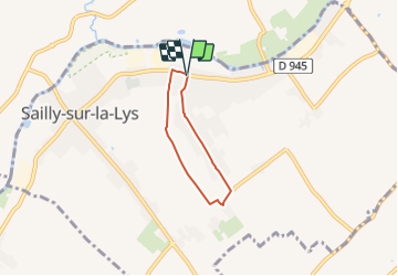
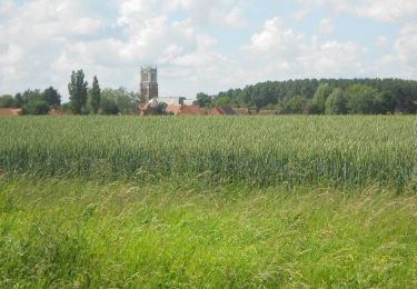
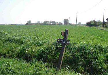
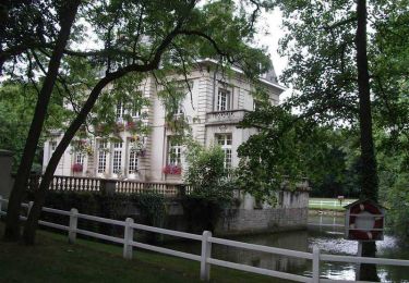
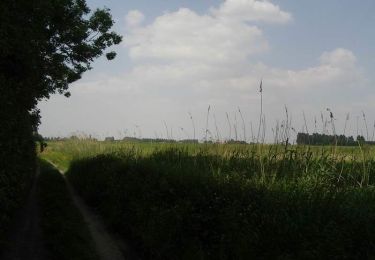
Randonnée A pied de 3,6 km à découvrir à Hauts-de-France, Pas-de-Calais, Sailly-sur-la-Lys. Cette randonnée est proposée par SityTrail - itinéraires balisés pédestres.

Profil altimétrique

Photos

Localisation

Pays :
France
Région :
Hauts-de-France
Département/Province :
Pas-de-Calais
Commune :
Sailly-sur-la-Lys
Localité :
Unknown
Départ:(UTM)
484934 ; 5612231 (31U) N.

Randonnées à proximité

Randonnée A pied Sailly-sur-la-Lys - Chemin Champêtre - Photo
A pied
GUIDE+

A pied

Facile
Sailly-sur-la-Lys, Hauts-de-France, Pas-de-Calais, France
9,1 km | 9,7 km-effort
2h 11min
Non
Randonnée A pied Sailly-sur-la-Lys - Chemin des Sûres - Photo
A pied
GUIDE+

A pied

Facile
Sailly-sur-la-Lys, Hauts-de-France, Pas-de-Calais, France
5,3 km | 5,5 km-effort
1h 14min
Non
Randonnée Marche Sailly-sur-la-Lys - Chemin Champêtre - Sailly-sur-la-Lys - Photo
Marche
Blourouce

Marche

Moyen
(1)
Sailly-sur-la-Lys, Hauts-de-France, Pas-de-Calais, France
9,7 km | 10,3 km-effort
2h 18min
Oui
Randonnée Marche Sailly-sur-la-Lys - Chemin Champêtre - Sailly sur la Lys - Photo
Marche
tracegps

Marche

Moyen
Sailly-sur-la-Lys, Hauts-de-France, Pas-de-Calais, France
9,7 km | 10,3 km-effort
2h 30min
Oui
Randonnée Marche Sailly-sur-la-Lys - Chemin de l'Alloeu - Sailly sur la Lys - Photo
Marche
tracegps

Marche

Facile
Sailly-sur-la-Lys, Hauts-de-France, Pas-de-Calais, France
4 km | 4,1 km-effort
1h 0min
Oui
Randonnée V.T.T. Le Doulieu - Circuit de la Gloriette - Le Doulieu - Photo
V.T.T.
tracegps

V.T.T.

Facile
Le Doulieu, Hauts-de-France, Nord, France
9,7 km | 10,1 km-effort
49min
Oui
Randonnée Marche Le Doulieu - Circuit de la Gloriette - Le Doulieu - Photo
Marche
tracegps

Marche

Moyen
Le Doulieu, Hauts-de-France, Nord, France
9,7 km | 10,1 km-effort
2h 25min
Oui
Randonnée Marche Nieppe - De Nieppe à la Lys - Photo
Marche
tracegps

Marche

Facile
Nieppe, Hauts-de-France, Nord, France
8,2 km | 8,6 km-effort
2h 0min
Oui
Randonnée Marche Steenwerck - Promenade en bord de Lys - Steenwerck - Photo
Marche
tracegps

Marche

Facile
(2)
Steenwerck, Hauts-de-France, Nord, France
4,7 km | 4,9 km-effort
1h 15min
Oui


Fermer
Mes abonnements