


Rb7

magbjo
Utilisateur
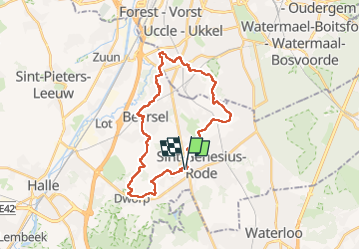

Longueur
26 km

Altitude max
128 m

Dénivelé positif
446 m
Km-Effort
32 km

Altitude min
26 m

Dénivelé négatif
443 m
Boucle
Oui
Date de création :
2022-05-08 06:28:07.0
Dernière modification :
2022-05-08 12:27:21.777
5h58
Difficulté : Très difficile

Application GPS de randonnée GRATUITE
 SityTrail
IGN / Instituts géographiques
SityTrail Plus
Le monde est à vous
À propos
Randonnée Marche de 26 km à découvrir à Flandre, Brabant flamand, Beersel. Cette randonnée est proposée par magbjo.
Localisation
Pays :
Belgique
Région :
Flandre
Département/Province :
Brabant flamand
Commune :
Beersel
Localité :
Alsemberg
Départ:(Dec)
Départ:(UTM)
594182 ; 5622097 (31U) N.
Commentaires