


congins

panetJeanLuc
Utilisateur
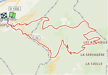

Longueur
17,4 km

Altitude max
1243 m

Dénivelé positif
1139 m
Km-Effort
33 km

Altitude min
275 m

Dénivelé négatif
1139 m
Boucle
Oui
Date de création :
2022-06-02 07:38:13.987
Dernière modification :
2022-06-02 15:03:49.758
4h21
Difficulté : Très difficile

Application GPS de randonnée GRATUITE
 SityTrail
IGN / Instituts géographiques
SityTrail Plus
Le monde est à vous
À propos
Randonnée Marche de 17,4 km à découvrir à Auvergne-Rhône-Alpes, Isère, Cognin-les-Gorges. Cette randonnée est proposée par panetJeanLuc.
Localisation
Pays :
France
Région :
Auvergne-Rhône-Alpes
Département/Province :
Isère
Commune :
Cognin-les-Gorges
Localité :
Unknown
Départ:(Dec)
Départ:(UTM)
689566 ; 5004745 (31T) N.
Commentaires