


GT DU VERCORS J2

nouga
Utilisateur
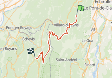

Longueur
47 km

Altitude max
1531 m

Dénivelé positif
1344 m
Km-Effort
67 km

Altitude min
713 m

Dénivelé négatif
1896 m
Boucle
Non
Date de création :
2022-06-29 08:32:39.161
Dernière modification :
2022-06-29 14:59:03.156
4h02
Difficulté : Très difficile

Application GPS de randonnée GRATUITE
 SityTrail
IGN / Instituts géographiques
SityTrail Plus
Le monde est à vous
À propos
Randonnée V.T.T. de 47 km à découvrir à Auvergne-Rhône-Alpes, Isère, Lans-en-Vercors. Cette randonnée est proposée par nouga.
Localisation
Pays :
France
Région :
Auvergne-Rhône-Alpes
Département/Province :
Isère
Commune :
Lans-en-Vercors
Localité :
Unknown
Départ:(Dec)
Départ:(UTM)
704328 ; 4997426 (31T) N.
Commentaires