


Falaën ADEPS

thomarche
Utilisateur
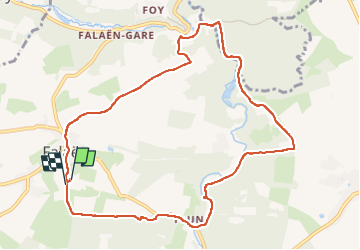

Longueur
9,8 km

Altitude max
246 m

Dénivelé positif
240 m
Km-Effort
13 km

Altitude min
126 m

Dénivelé négatif
243 m
Boucle
Oui
Date de création :
2022-07-03 12:09:07.0
Dernière modification :
2022-07-03 14:36:21.393
2h26
Difficulté : Très facile

Application GPS de randonnée GRATUITE
 SityTrail
IGN / Instituts géographiques
SityTrail Plus
Le monde est à vous
À propos
Randonnée Marche de 9,8 km à découvrir à Wallonie, Namur, Onhaye. Cette randonnée est proposée par thomarche.
Description
Boucle avc macadam peu fréquenté. Très beau village tout en pierres. ruines château Montaigle sentier long Flavion.
Localisation
Pays :
Belgique
Région :
Wallonie
Département/Province :
Namur
Commune :
Onhaye
Localité :
Unknown
Départ:(Dec)
Départ:(UTM)
627862 ; 5570768 (31U) N.
Commentaires