Randonnée Marche Souleuvre-en-Bocage - Autour du pont de la Souleuvre - Photo

Autour du pont de la Souleuvre

 phi14
phi14

Utilisateur

© OpenStreetMap contributors
Longueur
Longueur
14,2 km
Altitude max
Altitude max
180 m
Dénivelé positif
Dénivelé positif
294 m
Km-Effort
Km-Effort  
18,2 km
Altitude min
Altitude min
81 m
Dénivelé négatif
Dénivelé négatif
293 m
Boucle
Boucle
Oui
Date de création :
2014-12-10 00:00:00.0
Dernière modification :
2014-12-10 00:00:00.0

(0 Avis)

Marche
Marche
3h11
Difficulté : Facile

Scannez ce code QR pour ouvrir la randonnée dans l'application SityTrail

Application GPS de randonnée GRATUITE

Logo SityTrail SityTrail

IGN / Instituts géographiques

Télécharger SityTrail sur l'App Store Télécharger SityTrail sur Google Play

Logo SityTrail SityTrail World

Le monde est à vous

Télécharger SityTrail sur l'App Store Télécharger SityTrail sur Google Play Télécharger SityTrail sur Huawei AppGallery

À propos

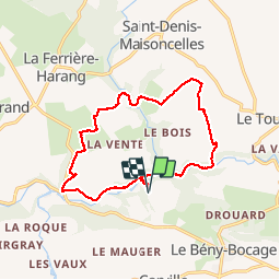
Randonnée Marche de 14,2 km à découvrir à Normandie, Calvados, Souleuvre-en-Bocage. Cette randonnée est proposée par phi14.

Description

04/08/2014
Aire de pique-nique agréable au plan d'eau de Beny-bocage.

Profil altimétrique

Localisation

Pays :
France
Région :
Normandie
Département/Province :
Calvados
Commune :
Souleuvre-en-Bocage
Localité :
Carville
Départ:(Dec)
Départ:(UTM)
656501 ; 5423986 (30U) N.

Randonnées à proximité

Randonnée V.T.T. Souleuvre-en-Bocage - rando de la souleuvre  - Photo
V.T.T.
mikeleguerrier

V.T.T.

Moyen
(1)
Souleuvre-en-Bocage, Normandie, Calvados, France
25 km | 32 km-effort
2h 7min
Oui
Randonnée Marche Souleuvre-en-Bocage - La vire - Photo
Marche
albers

Marche

Moyen
Souleuvre-en-Bocage, Normandie, Calvados, France
22 km | 28 km-effort
5h 0min
Oui
Randonnée V.T.T. Souleuvre-en-Bocage - Le long de la Souleuvre et de la Vire - Campeaux - Photo
V.T.T.
tracegps

V.T.T.

Difficile
Souleuvre-en-Bocage, Normandie, Calvados, France
53 km | 68 km-effort
5h 30min
Oui
Randonnée Marche Souleuvre-en-Bocage - Rando Viaduc de la souleuvre - Photo
Marche
Atchoum26

Marche

Facile
Souleuvre-en-Bocage, Normandie, Calvados, France
9,6 km | 12,2 km-effort
3h 2min
Non
Randonnée Marche Souleuvre-en-Bocage - LA SOULEUVRE EN BOUCLE - Photo
Marche
lensois

Marche

Très difficile
Souleuvre-en-Bocage, Normandie, Calvados, France
19,7 km | 25 km-effort
5h 40min
Oui
Randonnée Marche Souleuvre-en-Bocage - La souleuvre 2 - Photo
Marche
lensois

Marche

Moyen
Souleuvre-en-Bocage, Normandie, Calvados, France
7,7 km | 10,6 km-effort
2h 23min
Oui
Randonnée Marche Souleuvre-en-Bocage - La souleuvre 1 - Photo
Marche
lensois

Marche

Difficile
Souleuvre-en-Bocage, Normandie, Calvados, France
12,5 km | 16,5 km-effort
3h 44min
Oui
Randonnée Marche Souleuvre-en-Bocage - carville - Photo
Marche
Olivier.d

Marche

Facile
Souleuvre-en-Bocage, Normandie, Calvados, France
7,7 km | 9,8 km-effort
1h 49min
Oui
Randonnée A pied Souleuvre-en-Bocage - LE TOURNEUR 2 - Photo
A pied
lensois

A pied

Facile
Souleuvre-en-Bocage, Normandie, Calvados, France
8,6 km | 11,2 km-effort
2h 32min
Oui


Fermer
Mes abonnements