


col des mouilles-refuge jean collet

maupassant38
Utilisateur
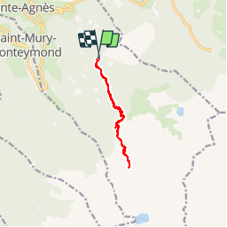

Longueur
11,2 km

Altitude max
2038 m

Dénivelé positif
816 m
Km-Effort
22 km

Altitude min
1299 m

Dénivelé négatif
817 m
Boucle
Oui
Date de création :
2019-02-22 22:32:03.678
Dernière modification :
2019-02-22 22:32:03.743
4h34
Difficulté : Moyen

Application GPS de randonnée GRATUITE
 SityTrail
IGN / Instituts géographiques
SityTrail Plus
Le monde est à vous
À propos
Randonnée Marche de 11,2 km à découvrir à Auvergne-Rhône-Alpes, Isère, Sainte-Agnès. Cette randonnée est proposée par maupassant38.
Description
col des mouilles-refuge jean collet
Photos

Localisation
Pays :
France
Région :
Auvergne-Rhône-Alpes
Département/Province :
Isère
Commune :
Sainte-Agnès
Localité :
Unknown
Départ:(Dec)
Départ:(UTM)
732004 ; 5011901 (31T) N.
Commentaires