![](/images/other/stat-length.png)
VTT de Spy.
pascalou73
Utilisateur GUIDE
![Longueur](/images/other/stat-length.png)
Longueur
48 km
![Altitude max](https://static1.geolcdn.com/siteimages/upload/files/1508320355ic_sort_altitude_max_24dp.png)
Altitude max
211 m
![Dénivelé positif](https://static1.geolcdn.com/siteimages/upload/files/1508320355ic_sort_den_pos_24dp.png)
Dénivelé positif
934 m
![Km-Effort](/images/other/stat-length.png)
Km-Effort
60 km
![Altitude min](https://static1.geolcdn.com/siteimages/upload/files/1508320355ic_sort_altitude_min_24dp.png)
Altitude min
80 m
![Dénivelé négatif](https://static1.geolcdn.com/siteimages/upload/files/1508320355ic_sort_den_neg_24dp.png)
Dénivelé négatif
933 m
![Boucle](https://static1.geolcdn.com/siteimages/upload/files/16400158638029165_repeat_loop_refresh_sync_direction_icon.png)
Boucle
Oui
Date de création :
2022-09-08 07:34:45.333
Dernière modification :
2022-09-08 07:36:16.797
![V.T.T.](https://static1.geolcdn.com/sitytour/trail-icons/202.png)
4h10
Difficulté : Très difficile
![Scannez ce code QR pour ouvrir la randonnée dans l'application SityTrail](https://capi.geolives.com/qq0zvz2zws4bq2lad0pu/sitytour/trails/3383433/qr.png?size=200)
Application GPS de randonnée GRATUITE
À propos
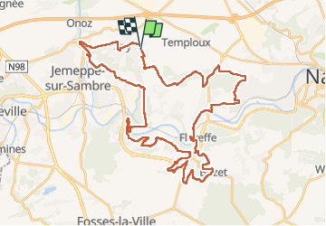
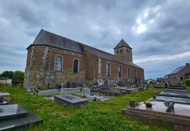
Randonnée V.T.T. de 48 km à découvrir à Wallonie, Namur, Jemeppe-sur-Sambre. Cette randonnée est proposée par pascalou73.
Description
Voila une belle randonnée au depart du village de Spy un V TT tres varier entre les bois et les campagnes et avec un beaux D .le top .
Localisation
Pays :
Belgique
Région :
Wallonie
Département/Province :
Namur
Commune :
Jemeppe-sur-Sambre
Localité :
Unknown
Départ:(Dec)
Départ:(UTM)
621819 ; 5593312 (31U) N.
Commentaires
Randonnées à proximité
![Randonnée Marche Jemeppe-sur-Sambre - RF-Na-01-Onoz_Petite-boucle - Photo](https://media.geolcdn.com/t/375/260/ext.jpg?maxdim=2&url=https%3A%2F%2Fservices.sitytrail.com%2FGeolivesWS%2FDownloadMedia.ashx%3FTrailID%3D545735%26Media%3Df68c7b52-4432-4018-b01d-0bb04e06ad16.jpg)
![Marche Marche](https://static1.geolcdn.com/sitytour/trail-icons/101.png)
RF-Na-01-Onoz_Petite-boucle
Marche
Facile
(10)
Jemeppe-sur-Sambre,
Wallonie,
Namur,
Belgique
![](/images/other/stat-length.png)
7,4 km | 8,9 km-effort
1h 59min
![](https://static1.geolcdn.com/siteimages/upload/files/16400158638029165_repeat_loop_refresh_sync_direction_icon.png)
Oui
![Randonnée Marche Floreffe - Promenade vers Soye par bois et champs - Photo](https://media.geolcdn.com/t/375/260/ext.jpg?maxdim=2&url=https%3A%2F%2Fstatic1.geolcdn.com%2Fsiteimages%2Fupload%2Ffiles%2F1553511878bg_sport_marche.png)
![Marche Marche](https://static1.geolcdn.com/sitytour/trail-icons/101.png)
Promenade vers Soye par bois et champs
Marche
Facile
(7)
Floreffe,
Wallonie,
Namur,
Belgique
![](/images/other/stat-length.png)
12,3 km | 15,3 km-effort
3h 0min
![](https://static1.geolcdn.com/siteimages/upload/files/16400158638029165_repeat_loop_refresh_sync_direction_icon.png)
Oui
![Randonnée Marche Namur - De Temploux à Suarlée - Photo](https://media.geolcdn.com/t/375/260/ext.jpg?maxdim=2&url=https%3A%2F%2Fservices.sitytrail.com%2FGeolivesWS%2FDownloadMedia.ashx%3FTrailID%3D187873%26Media%3D0f5c6b3b-618b-4553-bddc-22cf26058eb0.JPG)
![Marche Marche](https://static1.geolcdn.com/sitytour/trail-icons/101.png)
De Temploux à Suarlée
Marche
Facile
(1)
Namur,
Wallonie,
Namur,
Belgique
![](/images/other/stat-length.png)
10,7 km | 12,4 km-effort
2h 40min
![](https://static1.geolcdn.com/siteimages/upload/files/16400158638029165_repeat_loop_refresh_sync_direction_icon.png)
Oui
![Randonnée Marche Jemeppe-sur-Sambre - La petite boucle de Onoz - Photo](https://media.geolcdn.com/t/375/260/ext.jpg?maxdim=2&url=https%3A%2F%2Fmedia.geolcdn.com%2Ff%2F728a8926-dea5-48ea-8a91-8a3e4029625e.jpg)
![Marche Marche](https://static1.geolcdn.com/sitytour/trail-icons/101.png)
La petite boucle de Onoz
Marche
Facile
(3)
Jemeppe-sur-Sambre,
Wallonie,
Namur,
Belgique
![](/images/other/stat-length.png)
7 km | 8,4 km-effort
1h 57min
![](https://static1.geolcdn.com/siteimages/upload/files/16400158638029165_repeat_loop_refresh_sync_direction_icon.png)
Oui
![Randonnée Marche Floreffe - Franiere Temploux-corona2020-20Km - Photo](https://media.geolcdn.com/t/375/260/ext.jpg?maxdim=2&url=https%3A%2F%2Fmedia.geolcdn.com%2Ff%2F378c143f-9d2f-4550-82c1-b14c9446142e.JPG)
![Marche Marche](https://static1.geolcdn.com/sitytour/trail-icons/101.png)
Franiere Temploux-corona2020-20Km
Marche
Facile
(1)
Floreffe,
Wallonie,
Namur,
Belgique
![](/images/other/stat-length.png)
20 km | 24 km-effort
4h 0min
![](https://static1.geolcdn.com/siteimages/upload/files/16400158638029165_repeat_loop_refresh_sync_direction_icon.png)
Oui
![Randonnée Marche Jemeppe-sur-Sambre - RF-Na-01-Onoz_Grande-boucle - Photo](https://media.geolcdn.com/t/375/260/ext.jpg?maxdim=2&url=https%3A%2F%2Fservices.sitytrail.com%2FGeolivesWS%2FDownloadMedia.ashx%3FTrailID%3D545736%26Media%3Dca5596bc-2473-4f40-bb0a-21932020469e.jpg)
![Marche Marche](https://static1.geolcdn.com/sitytour/trail-icons/101.png)
RF-Na-01-Onoz_Grande-boucle
Marche
Moyen
(7)
Jemeppe-sur-Sambre,
Wallonie,
Namur,
Belgique
![](/images/other/stat-length.png)
8,8 km | 10,5 km-effort
2h 19min
![](https://static1.geolcdn.com/siteimages/upload/files/16400158638029165_repeat_loop_refresh_sync_direction_icon.png)
Oui
![Randonnée Marche Floreffe - Franiere - Promenade au bois de Roly - Photo](https://media.geolcdn.com/t/375/260/ext.jpg?maxdim=2&url=https%3A%2F%2Fstatic1.geolcdn.com%2Fsiteimages%2Fupload%2Ffiles%2F1553511878bg_sport_marche.png)
![Marche Marche](https://static1.geolcdn.com/sitytour/trail-icons/101.png)
Franiere - Promenade au bois de Roly
Marche
Très facile
(3)
Floreffe,
Wallonie,
Namur,
Belgique
![](/images/other/stat-length.png)
4 km | 5,3 km-effort
1h 0min
![](https://static1.geolcdn.com/siteimages/upload/files/16400158638029165_repeat_loop_refresh_sync_direction_icon.png)
Oui
![Randonnée V.T.T. Jemeppe-sur-Sambre - O2bikers_126_spy - Photo](https://media.geolcdn.com/t/375/260/ext.jpg?maxdim=2&url=https%3A%2F%2Fstatic1.geolcdn.com%2Fsiteimages%2Fupload%2Ffiles%2F1524743154velo.jpg)
![V.T.T. V.T.T.](https://static1.geolcdn.com/sitytour/trail-icons/202.png)
O2bikers_126_spy
V.T.T.
Très facile
(3)
Jemeppe-sur-Sambre,
Wallonie,
Namur,
Belgique
![](/images/other/stat-length.png)
32 km | 39 km-effort
5h 19min
![](https://static1.geolcdn.com/siteimages/upload/files/16400158638029165_repeat_loop_refresh_sync_direction_icon.png)
Oui
![Randonnée Marche Gembloux - Balade à Bossière - Gembloux - Photo](https://media.geolcdn.com/t/375/260/ext.jpg?maxdim=2&url=https%3A%2F%2Fmedia.geolcdn.com%2Ff%2F60cbd9cf-8e4d-4bbf-889b-adeed6ff6542.jpeg)
![Marche Marche](https://static1.geolcdn.com/sitytour/trail-icons/101.png)
Balade à Bossière - Gembloux
Marche
Moyen
Gembloux,
Wallonie,
Namur,
Belgique
![](/images/other/stat-length.png)
9,4 km | 11,1 km-effort
2h 31min
![](https://static1.geolcdn.com/siteimages/upload/files/16400158638029165_repeat_loop_refresh_sync_direction_icon.png)
Oui
super