


SityTrail - Aigurande - la Vauvre

jeanmarcMasson
Utilisateur GUIDE
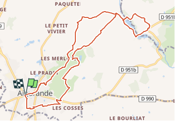

Longueur
12,3 km

Altitude max
441 m

Dénivelé positif
236 m
Km-Effort
15,4 km

Altitude min
322 m

Dénivelé négatif
237 m
Boucle
Oui
Date de création :
2022-09-28 07:18:27.616
Dernière modification :
2022-09-28 07:26:03.301
3h30
Difficulté : Difficile

Application GPS de randonnée GRATUITE
 SityTrail
IGN / Instituts géographiques
SityTrail Plus
Le monde est à vous
À propos
Randonnée Marche de 12,3 km à découvrir à Centre-Val de Loire, Indre, Aigurande. Cette randonnée est proposée par jeanmarcMasson.
Localisation
Pays :
France
Région :
Centre-Val de Loire
Département/Province :
Indre
Commune :
Aigurande
Localité :
Unknown
Départ:(Dec)
Départ:(UTM)
409847 ; 5142942 (31T) N.
Commentaires