


vers_piste_descente_bleue

PhilippeC54
Utilisateur
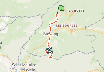

Longueur
7,1 km

Altitude max
1010 m

Dénivelé positif
415 m
Km-Effort
12,1 km

Altitude min
595 m

Dénivelé négatif
234 m
Boucle
Non
Date de création :
2022-10-25 08:00:15.502
Dernière modification :
2022-10-25 08:00:15.502
50m
Difficulté : Facile

Application GPS de randonnée GRATUITE
 SityTrail
IGN / Instituts géographiques
SityTrail Plus
Le monde est à vous
À propos
Randonnée V.T.T. de 7,1 km à découvrir à Grand Est, Vosges, Bussang. Cette randonnée est proposée par PhilippeC54.
Localisation
Pays :
France
Région :
Grand Est
Département/Province :
Vosges
Commune :
Bussang
Localité :
Unknown
Départ:(Dec)
Départ:(UTM)
340318 ; 5307512 (32T) N.
Commentaires